IMAGES TAKEN NEAR TO
Bexfield Road, DEREHAM, NR20 5SB
Introduction
This page details the photographs taken nearby to Bexfield Road, NR20 5SB by members of the Geograph project.
The Geograph project started in 2005 with the aim of publishing, organising and preserving representative images for every square kilometre of Great Britain, Ireland and the Isle of Man.

There are currently over 7.5m images from over14,400 individuals and you can help contribute to the project by visiting https://www.geograph.org.uk
Image Map
Images are licensed for reuse under creativecommons.org/licenses/by-sa/2.0
Notes
- Clicking on the map will re-center to the selected point.
- The higher the marker number, the further away the image location is from the centre of the postcode.
Image Listing (31 Images Found)
Images are licensed for reuse under creativecommons.org/licenses/by-sa/2.0
Image
Details
Distance

4
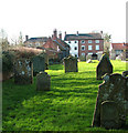
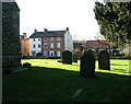
View to High Street from the churchyard, Foulsham
The village of Foulsham is situated south-east of Fakenham, close to the A1067 (Norwich to Fakenham) road. In summer 1770 a devastating fire caused considerable damage to the village, destroying a number of buildings.
Image: © Evelyn Simak
Taken: 8 Feb 2011
0.20 miles
5
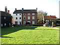
Houses in High Street, Foulsham
The village of Foulsham is situated south-east of Fakenham, close to the A1067 (Norwich to Fakenham) road. In summer 1770 a devastating fire caused considerable damage to the village, destroying a number of buildings.
Image: © Evelyn Simak
Taken: 8 Feb 2011
0.20 miles
6
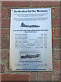
Memorial to mid-air collision at Foulsham
The fatal accident occurred on 31st August 1943 when a B-17, Flying Fortress and a Beaufighter collided over Foulsham.
Two of the B-17 crew parachuted to safety but the eight other crew-members were killed. The Pilot and Observer of the Beaufighter were also killed.
A general view of the location can be seen here > https://www.geograph.org.uk/photo/6378523
Image: © Adrian S Pye
Taken: 29 Jan 2020
0.22 miles
7
Memorial to mid-air collision at Foulsham
The fatal accident occurred on 31st August 1943 when a B-17, Flying Fortress and a Beaufighter collided over Foulsham.
Two of the B-17 crew parachuted to safety but the eight other crew-members were killed. The Pilot and Observer of the Beaufighter were also killed.
A close look of the plaque can be seen here > https://www.geograph.org.uk/photo/6378528
Image: © Adrian S Pye
Taken: 29 Jan 2020
0.22 miles
8
High Street houses seen from the churchyard, Foulsham
The village of Foulsham is situated south-east of Fakenham, close to the A1067 (Norwich to Fakenham) road. In summer 1770 a devastating fire caused considerable damage to the village, destroying a number of buildings.
Image: © Evelyn Simak
Taken: 8 Feb 2011
0.22 miles
9
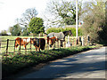
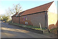
Pasture and occupants beside The Street in Foulsham
Image: © Evelyn Simak
Taken: 8 Feb 2011
0.22 miles