IMAGES TAKEN NEAR TO
Yaxham Road, DEREHAM, NR19 1JQ
Introduction
This page details the photographs taken nearby to Yaxham Road, NR19 1JQ by members of the Geograph project.
The Geograph project started in 2005 with the aim of publishing, organising and preserving representative images for every square kilometre of Great Britain, Ireland and the Isle of Man.

There are currently over 7.5m images from over14,400 individuals and you can help contribute to the project by visiting https://www.geograph.org.uk
Image Map
Images are licensed for reuse under creativecommons.org/licenses/by-sa/2.0
Notes
- Clicking on the map will re-center to the selected point.
- The higher the marker number, the further away the image location is from the centre of the postcode.
Image Listing (16 Images Found)
Images are licensed for reuse under creativecommons.org/licenses/by-sa/2.0
Image
Details
Distance
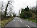
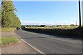
2
Traffic on the B1135
The red car is heading to a sharpish bend. Seen from the railway line.
Image: © Christine Johnstone
Taken: 23 May 2018
0.06 miles
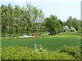
3
Yaxham Road, Dereham
Woodland by the River Tud by Dereham Bridge
Image: © David Howard
Taken: 19 Jul 2020
0.08 miles
4
Trees along the B1135
Looking eastwards from a Mid-Norfolk Railway train. For a view of these trees from the road, see Image
Image: © Christine Johnstone
Taken: 23 May 2018
0.10 miles
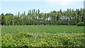
5
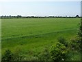
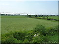
Cereal field on the southern edge of Dereham
Looking west from the Mid-Norfolk Railway.
Image: © Christine Johnstone
Taken: 23 May 2018
0.10 miles
6
Fields Near Yaxham
Viewed from the Mid-Norfolk Railway on a disappointingly dull June afternoon.
Image: © Mary and Angus Hogg
Taken: 24 Jun 2017
0.14 miles
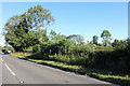
7
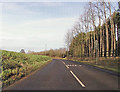
Entering East Dereham on Yaxham Road (B1135)
Image: © Adrian S Pye
Taken: 15 Dec 2014
0.15 miles
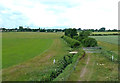
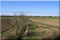
9
The shallow valley of the River Tud, south of Dereham
The river is marked by the hedges. It must have been straightened, as the civil parish boundary wiggles alongside, to the south/left.
Image: © Christine Johnstone
Taken: 23 May 2018
0.16 miles
10
Track near Watering Farm
A photographer stands beside the track near Watering Farm, photographing a southbound train. The track passes beneath the railway line and this image was taken from the train.
Image: © Glen Denny
Taken: 19 Mar 2011
0.17 miles