IMAGES TAKEN NEAR TO
NR18 8FA
Introduction
This page details the photographs taken nearby to NR18 8FA by members of the Geograph project.
The Geograph project started in 2005 with the aim of publishing, organising and preserving representative images for every square kilometre of Great Britain, Ireland and the Isle of Man.

There are currently over 7.5m images from over14,400 individuals and you can help contribute to the project by visiting https://www.geograph.org.uk
Image Map
Images are licensed for reuse under creativecommons.org/licenses/by-sa/2.0
Notes
- Clicking on the map will re-center to the selected point.
- The higher the marker number, the further away the image location is from the centre of the postcode.
Image Listing (272 Images Found)
Images are licensed for reuse under creativecommons.org/licenses/by-sa/2.0
Image
Details
Distance
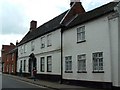
2
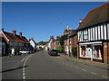
Wymondham Town Hall
Early C19 house on Middleton Street; listed by Historic England (Grade II): http://www.imagesofengland.org.uk/Details/Default.aspx?id=386195&mode=adv
Image: © Mike Faherty
Taken: 6 Nov 2016
0.03 miles
3
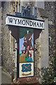
Wymondham town sign
Signs in this style are common throughout East Anglia. Wymondham's monastic history is depicted by the monk and the abbey church; below the name is a reminder of Kett's rebellion in the 16th century.
Image: © Stephen McKay
Taken: 20 Mar 2011
0.04 miles
5
Wymondham Library
Wymondham Library, a former medieval chapel.
Image: © David Robertson
Taken: 28 May 2005
0.05 miles
6
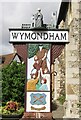
Wymondham - Town Sign
Civic landmark portraying a monk, the Benedictine abbey church and Kett's rebellion of the 16th century.
Image: © Colin Smith
Taken: 21 Aug 2020
0.05 miles
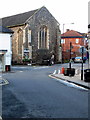
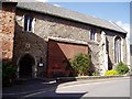
7
Wymondham Arts Centre
At the corner of Middleton and Church Streets; formerly a C12 chapel (Historic England Grade I listed), later library, now arts centre. http://www.imagesofengland.org.uk/Details/Default.aspx?id=386104&mode=adv
Image: © Mike Faherty
Taken: 4 Nov 2016
0.05 miles
8
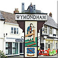
Wymondham town sign
The sign at Wymondham is in the usual “T” shape to denote a town sign. It is surmounted by a representation of the abbey and a praying figure.
It is double sided and both sides depict scenes from the Wymondham past wood turning industry. In the lower panel both sides are spoons as would have been manufactured by the wood-turners and the words which came to be pronounced Wymondham, ‘Win Munte Ham’, meaning the village on the pleasant mound. On the other side is the rebellious rabble rouser William Kett standing under ‘Kett’s oak’ who was hanged twice. For his deeds he was hanged from the walls of Norwich Castle on 7 December 1549; on the same day he was hanged from the west tower of Wymondham Abbey. https://www.geograph.org.uk/photo/6805305
Image: © Adrian S Pye
Taken: 8 Apr 2021
0.05 miles
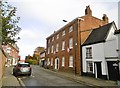
9
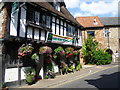
The Green Dragon, Wymondham
The Green Dragon dates from the late 15th century. It once served as a hostelry for visitors to the Abbey. It is the oldest inn in Wymondham. Beyond is Becket's Chapel.
The chapel was founded in 1174 by William d'Albini, the son of the founder of Wymondham Abbey. During the Middle Ages it became a guild chapel, and each guild kept a light burning there. After the Dissolution of the Monasteries it fell into disrepair but in 1559 it was converted for use as a grammar school. The school moved in the early 1800s after which it was used to store coal. From 1931 until 2008 the chapel housed Wymondham Library but since 2009 it has been used as the town's Arts Centre.
Image: © Marathon
Taken: 19 Aug 2015
0.05 miles