IMAGES TAKEN NEAR TO
Arlington Gardens, ATTLEBOROUGH, NR17 2ND
Introduction
This page details the photographs taken nearby to Arlington Gardens, NR17 2ND by members of the Geograph project.
The Geograph project started in 2005 with the aim of publishing, organising and preserving representative images for every square kilometre of Great Britain, Ireland and the Isle of Man.

There are currently over 7.5m images from over14,400 individuals and you can help contribute to the project by visiting https://www.geograph.org.uk
Image Map
Images are licensed for reuse under creativecommons.org/licenses/by-sa/2.0
Notes
- Clicking on the map will re-center to the selected point.
- The higher the marker number, the further away the image location is from the centre of the postcode.
Image Listing (79 Images Found)
Images are licensed for reuse under creativecommons.org/licenses/by-sa/2.0
Image
Details
Distance
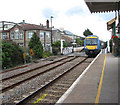
1
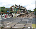
Attleborough railway station - view across Station Road
Attleborough > http://www.geograph.org.uk/photo/1408035 started out as a station of the Norfolk Railway and was later run by the Great Eastern Railway, before becoming part of the London and North Eastern Railway in 1923. As part of the 'Rural Stations Restaffing Initiative' a new Ticket Office opened in 2008, and presently the station is served by local services operated by East Midlands Trains and the Breckland Line, running from Norwich to Ely, Cambridge and Peterborough. The old signal box > http://www.geograph.org.uk/photo/1408045 is still in place and staffed, and the crossing gates > http://www.geograph.org.uk/photo/1407986 on Station Road (B 1077) have to be manually closed and opened by the signalman
Image: © Evelyn Simak
Taken: 20 Jul 2009
0.14 miles
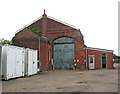
2
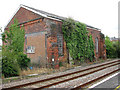
Attleborough railway station - the former goods shed
See also > http://www.geograph.org.uk/photo/1408104. For a view of the station see > http://www.geograph.org.uk/photo/1408035.
Image: © Evelyn Simak
Taken: 20 Jul 2009
0.15 miles
3
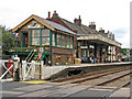
Attleborough railway station
Attleborough started out as a station of the Norfolk Railway and was later run by the Great Eastern Railway, before becoming part of the London and North Eastern Railway in 1923. As part of the 'Rural Stations Restaffing Initiative' a new Ticket Office opened in 2008, and presently the station is served by local services operated by East Midlands Trains and the Breckland Line, running from Norwich to Ely, Cambridge and Peterborough. The old signal box > http://www.geograph.org.uk/photo/1408045 is still in place and staffed, and the crossing gates > http://www.geograph.org.uk/photo/1407986 on Station Road (B 1077) have to be manually closed and opened by the signalman
Image: © Evelyn Simak
Taken: 20 Jul 2009
0.16 miles
4
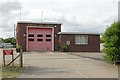
Attleborough fire station
Attleborough fire station, Thieves Lane, Attleborough, Norfolk
Image: © Kevin Hale
Taken: 6 Jun 2009
0.16 miles
5
Attleborough railway station - train arriving at platform 1
This train is heading in the direction of Wymondham. Trains to Ely, Cambridge and Peterborough stop at platform 2 > http://www.geograph.org.uk/photo/1408010 which is on the other side of Station Road.
Attleborough > http://www.geograph.org.uk/photo/1408035 started out as a station of the Norfolk Railway and was later run by the Great Eastern Railway, before becoming part of the London and North Eastern Railway in 1923. As part of the 'Rural Stations Restaffing Initiative' a new Ticket Office opened in 2008, and presently the station is served by local services operated by East Midlands Trains and the Breckland Line, running from Norwich to Ely, Cambridge and Peterborough. The old signal box > http://www.geograph.org.uk/photo/1408045 is still in place and staffed, and the crossing gates > http://www.geograph.org.uk/photo/1407986 on Station Road (B 1077) have to be manually closed and opened by the signalman
Image: © Evelyn Simak
Taken: 20 Jul 2009
0.16 miles
6
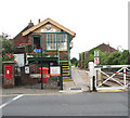
Attleborough railway station - signal box and goods shed
This is the entrance to platform 1, the former goods shed > http://www.geograph.org.uk/photo/1408104 can be seen in the background (at right). For a close-up view of the George VI wallbox see > http://www.geograph.org.uk/photo/1408053.
Attleborough > http://www.geograph.org.uk/photo/1408035 started out as a station of the Norfolk Railway and was later run by the Great Eastern Railway, before becoming part of the London and North Eastern Railway in 1923. As part of the 'Rural Stations Restaffing Initiative' a new Ticket Office opened in 2008, and presently the station is served by local services operated by East Midlands Trains and the Breckland Line, running from Norwich to Ely, Cambridge and Peterborough. The old signal box > http://www.geograph.org.uk/photo/1408045 is still in place and staffed, and the crossing gates > http://www.geograph.org.uk/photo/1407986 on Station Road (B 1077) have to be manually closed and opened by the signalman.
Image: © Evelyn Simak
Taken: 20 Jul 2009
0.16 miles
7
Attleborough railway station - the former goods shed
See also > http://www.geograph.org.uk/photo/1408098. For a view of the station see > http://www.geograph.org.uk/photo/1408035.
Image: © Evelyn Simak
Taken: 20 Jul 2009
0.17 miles
8
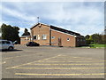
Connaught Hall, Attleborough
Off the B1077 Station Road
http://www.attleboroughsurgeries.com/
Image: © Geographer
Taken: 23 Sep 2016
0.17 miles
9
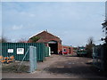
Attleborough station goods shed
The ivy clad brick goods shed is a clue to the once extensive freight traffic handled here including Gaymer’s cider which was served in the refreshment rooms of the Great Eastern Railway. The cider works moved alongside the railway in 1896 had extensive sidings and stood on the site of the present Banham poultry plant.
Image: © Ashley Dace
Taken: 7 Mar 2009
0.17 miles
10
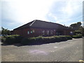
Attleborough Health Clinic, Attleborough
Off the B1077 Station Road
http://www.attleboroughsurgeries.com/
Image: © Geographer
Taken: 23 Sep 2016
0.17 miles