IMAGES TAKEN NEAR TO
Hawes Green, NORWICH, NR15 1UL
Introduction
This page details the photographs taken nearby to Hawes Green, NR15 1UL by members of the Geograph project.
The Geograph project started in 2005 with the aim of publishing, organising and preserving representative images for every square kilometre of Great Britain, Ireland and the Isle of Man.

There are currently over 7.5m images from over14,400 individuals and you can help contribute to the project by visiting https://www.geograph.org.uk
Image Map
Images are licensed for reuse under creativecommons.org/licenses/by-sa/2.0
Notes
- Clicking on the map will re-center to the selected point.
- The higher the marker number, the further away the image location is from the centre of the postcode.
Image Listing (68 Images Found)
Images are licensed for reuse under creativecommons.org/licenses/by-sa/2.0
Image
Details
Distance
1
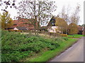
Houses at Hawes Green
These houses are on the upper sides of a river valley and have great views of Shotesham village and its common to the east.
Image: © Jon Welch
Taken: 14 Nov 2006
0.12 miles
2
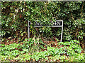
Hawes Green sign
On Hawes Green at the junction with Priory Road
Image: © Geographer
Taken: 28 Feb 2014
0.13 miles
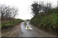
3

Hawes Green
At the junction with Priory Lane
Image: © Geographer
Taken: 28 Feb 2014
0.13 miles
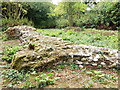
4
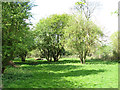
View across the site of St Botolph's church
This is the site of St Botolph’s church which was destroyed during the Reformation. In 1965 a number of medieval and post medieval pottery sherds were recovered from here but in 1976 only a few overgrown humps remained and until recently the whole site was covered in thick undergrowth until in 2013 the site was cleared and made accessible. Only a small part of the west wall of the square tower and possible evidence of a buttress remain. A bench was put up at the far end of the site > http://www.geograph.org.uk/photo/3925311.
The other three churches in the parish are St Mary's http://www.geograph.org.uk/photo/1372461 which is only a short distance away from the ruined church of St Martin > http://www.geograph.org.uk/photo/1372643 also recently cleared of vegetation, and All Saints > http://www.geograph.org.uk/photo/1371795.
Image: © Evelyn Simak
Taken: 11 Apr 2014
0.13 miles
5
The site of St Botolph's church
This is the site of St Botolph’s church which was destroyed during the Reformation. In 1965 a number of medieval and post medieval pottery sherds were recovered from here but in 1976 only a few overgrown humps remained and until recently the whole site was covered in thick undergrowth until in 2013 the site was cleared and made accessible. Only a small part of the west wall of the square tower and possible evidence of a buttress remain. A bench was put up at the far end of the site > http://www.geograph.org.uk/photo/3925311.
The other three churches in the parish are St Mary's http://www.geograph.org.uk/photo/1372461 which is only a short distance away from the ruined church of St Martin > http://www.geograph.org.uk/photo/1372643 also recently cleared of vegetation, and All Saints > http://www.geograph.org.uk/photo/1371795.
Image: © Evelyn Simak
Taken: 11 Apr 2014
0.14 miles
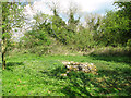
6
Shotesham St. Botolph ruin
Of the fourth church in this parish, only a fragment remains, it used to be hidden in a very overgrown copse, but recently the P.C.C and the Shotesham gardening and conservation group have cleared the site and made the ruin accessible to the public, and landscaped the area around it.
Just the foundations of the west wall of the tower remain complete with buttresses.
The church was demolished on the orders of Henry VIII, after a dispute with the Abbot of St Benet's..
Image: © Adrian Mitchell
Taken: 22 Aug 2013
0.14 miles
7
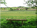
Bench on the site of St Botolph's church
With an open view towards houses in Shotesham.
Image: © Evelyn Simak
Taken: 11 Apr 2014
0.15 miles
8
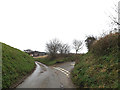
Priory Lane, Hawes Green
At the junction with Hollow Lane
Image: © Geographer
Taken: 28 Feb 2014
0.16 miles
9
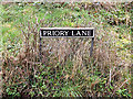
Priory Lane sign
On Priory Lane at the junction with Hollow Lane
Image: © Geographer
Taken: 28 Feb 2014
0.16 miles
10
Priory Lane, Hawes Green
At the junction with Hollow Lane
Image: © Geographer
Taken: 28 Feb 2014
0.16 miles