IMAGES TAKEN NEAR TO
The Street, NORWICH, NR15 1SL
Introduction
This page details the photographs taken nearby to The Street, NR15 1SL by members of the Geograph project.
The Geograph project started in 2005 with the aim of publishing, organising and preserving representative images for every square kilometre of Great Britain, Ireland and the Isle of Man.

There are currently over 7.5m images from over14,400 individuals and you can help contribute to the project by visiting https://www.geograph.org.uk
Image Map
Images are licensed for reuse under creativecommons.org/licenses/by-sa/2.0
Notes
- Clicking on the map will re-center to the selected point.
- The higher the marker number, the further away the image location is from the centre of the postcode.
Image Listing (45 Images Found)
Images are licensed for reuse under creativecommons.org/licenses/by-sa/2.0
Image
Details
Distance
1
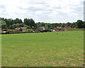
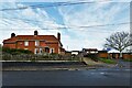
Houses in the village of Hapton
View across paddock towards houses located along The Street in the village of Hapton. The Tas Valley Way leads past here.
This section of the Tas Valley Way leads from Flordon St Michael's > http://www.geograph.org.uk/photo/1385205 to Hapton St Margaret's church > http://www.geograph.org.uk/photo/1385198 further to the south-west. The walk traverses the Hapton Estate > http://www.geograph.org.uk/photo/1385241 and Parkland Rehoming Centre, managed by the Redwings Horse Sanctuary with their Norfolk headquarters housed in Hapton Hall > http://www.geograph.org.uk/photo/1385721. The site comprises a specialist horse hospital (the Mrs Coco Markus Veterinary Hospital) which has its own x-ray room and operating theatre, intensive care stables and a pharmacy > http://www.geograph.org.uk/photo/1385730 as well as a rehoming centre, admin offices and more than 300 acres of paddocks > http://www.geograph.org.uk/photo/1385256 and is open to the public on two weekends per year only.
The Tas Valley Way is a long distance footpath which links Eaton and Attleborough. It connects with Kett's Country Walk and with the Yare Valley Walk - leading through a landscape which was shaped by the Enclosure Acts and where public access is now generally restricted to roads and public rights of way. The Tas Valley Way leads through 16 villages and past 16 churches. The walk starts by the ancient bridge at Cringleford and ends at St Mary's church in Attleborough > http://www.geograph.org.uk/photo/701948.
Image: © Evelyn Simak
Taken: 4 Jul 2009
0.02 miles
2
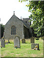
St Margaret's church
St Margaret's is located by the junction of Norwich Road and Cow Lane. The church is kept locked, a key is available.
Image: © Evelyn Simak
Taken: 4 Jul 2009
0.07 miles
3
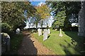
St Margaret, Hapton, Norfolk - Churchyard
Image: © John Salmon
Taken: 27 Oct 2008
0.07 miles
5
St Margaret, Hapton, Norfolk - Churchyard
Image: © John Salmon
Taken: 27 Oct 2008
0.07 miles
6
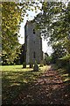
St Margaret, Hapton, Norfolk - West end
Image: © John Salmon
Taken: 27 Oct 2008
0.07 miles
9
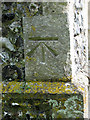
St Margaret's church in Hapton - benchmark
This cut mark can be found on the north-west corner of the tower of St Margaret's church > http://www.geograph.org.uk/photo/1385198. It is listed in the Bench Mark Database: https://mail.google.com/mail/?ui=2&view=bsp&ver=ohhl4rw8mbn4.
Image: © Evelyn Simak
Taken: 22 Aug 2010
0.07 miles
10
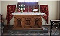
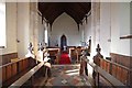
St Margaret, Hapton, Norfolk - Sanctuary
Image: © John Salmon
Taken: 27 Oct 2008
0.07 miles