IMAGES TAKEN NEAR TO
Critoph Close, NORWICH, NR14 7LF
Introduction
This page details the photographs taken nearby to Critoph Close, NR14 7LF by members of the Geograph project.
The Geograph project started in 2005 with the aim of publishing, organising and preserving representative images for every square kilometre of Great Britain, Ireland and the Isle of Man.

There are currently over 7.5m images from over14,400 individuals and you can help contribute to the project by visiting https://www.geograph.org.uk
Image Map
Images are licensed for reuse under creativecommons.org/licenses/by-sa/2.0
Notes
- Clicking on the map will re-center to the selected point.
- The higher the marker number, the further away the image location is from the centre of the postcode.
Image Listing (190 Images Found)
Images are licensed for reuse under creativecommons.org/licenses/by-sa/2.0
Image
Details
Distance
1
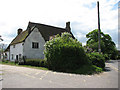
Church Farm
The farm is located opposite the road from All Saints church > http://www.geograph.org.uk/photo/1285057.
Image: © Evelyn Simak
Taken: 3 May 2009
0.04 miles
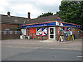
2
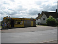
Premier Foodstore
... by the junction of Rectory Lane with the B1332 (Bungay Road).
Image: © Evelyn Simak
Taken: 3 May 2009
0.06 miles
3
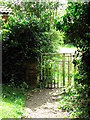
Gate into All Saints' churchyard
For a view of the church see > http://www.geograph.org.uk/photo/1285057.
Image: © Evelyn Simak
Taken: 3 May 2009
0.06 miles
4
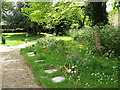
All Saints Church - path through churchyard
For a view of the church see > http://www.geograph.org.uk/photo/1285057.
Image: © Evelyn Simak
Taken: 3 May 2009
0.06 miles
5
Poringland Shop and Post Office
Shop and post office adjoin all Saints church > http://www.geograph.org.uk/photo/1285057 in the south.
Nov 2009 - Post Office and shop are now closed.
Image: © Evelyn Simak
Taken: 3 May 2009
0.07 miles
6
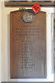
Poringland WW1 War Memorial
This memorial is in the south porch of All Saints church.
For details see https://www.geograph.org.uk/photo/6584665
Image: © Adrian S Pye
Taken: 30 Aug 2020
0.07 miles
7
Poringland WW2 War Memorial
This memorial is in the south porch of All Saints church.
For details see https://www.geograph.org.uk/photo/6584665
Image: © Adrian S Pye
Taken: 30 Aug 2020
0.07 miles
8
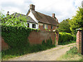
Church Cottage
Church Cottage adjoins All Saints church > http://www.geograph.org.uk/photo/1285057 in the southwest.
Image: © Evelyn Simak
Taken: 3 May 2009
0.07 miles
9
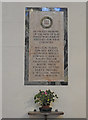
Poringland WW1 War Memorial in the church
This memorial is on the south wall of the nave of All Saints church.
For details see https://www.geograph.org.uk/photo/6584665
Image: © Adrian S Pye
Taken: 30 Aug 2020
0.07 miles
10
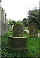
All Saints Church - churchyard
The old headstones stand on the south side of All Saints church, the path leading past here leads to the lych gate at The Street (B1332). For a view of the church see > http://www.geograph.org.uk/photo/1285057.
Image: © Evelyn Simak
Taken: 3 May 2009
0.08 miles