
IMAGES TAKEN NEAR TO
Hill House Road, NORWICH, NR14 7EG
Introduction
This page details the photographs taken nearby to Hill House Road, NR14 7EG by members of the Geograph project.
The Geograph project started in 2005 with the aim of publishing, organising and preserving representative images for every square kilometre of Great Britain, Ireland and the Isle of Man.

There are currently over 7.5m images from over14,400 individuals and you can help contribute to the project by visiting https://www.geograph.org.uk
Image Map
Images are licensed for reuse under creativecommons.org/licenses/by-sa/2.0
Notes
- Clicking on the map will re-center to the selected point.
- The higher the marker number, the further away the image location is from the centre of the postcode.
Image Listing (247 Images Found)
Images are licensed for reuse under creativecommons.org/licenses/by-sa/2.0
Image
Details
Distance


3

Cruiser travelling down the River Yare
Image: © Evelyn Simak
Taken: 23 Jun 2009
0.02 miles
4

An unusually quiet River Yare
Moored here is S332, a private sailing yacht named 'Phantom'. It was designed by Jan Proctor and built by Rydgeway Marine/Pegasus Yachts at Oulton Broad. The River Yare is very quiet these days. Ever since the lockdown due to the Coronavirus pandemic which had been imposed on 23 March most businesses, including boat yards, are closed. The lockdown was eased on 13 May (a day before this photo was taken) and private boats are now again allowed to travel on England's rivers. Hire boats, however, make up for the bulk of river traffic in this area.
Image: © Evelyn Simak
Taken: 14 May 2020
0.04 miles
5

The Wherryman's Way - to Bramerton Common
Here the path leads through private property, skirting the riverside gardens of adjoining houses. The walk > http://www.geograph.org.uk/photo/1358319 starts by St Mary's church > http://www.geograph.org.uk/photo/1280845 leading in westerly direction. It winds its way downwards > http://www.geograph.org.uk/photo/1358328 to the River Yare, following a woodland edge before it reaches the bottom of the valley and the reed beds growing beside the river > http://www.geograph.org.uk/photo/1358349. A footbridge > http://www.geograph.org.uk/photo/1358351 leads over a drainage ditch and a short walk > http://www.geograph.org.uk/photo/1358355 leads to the river bank > http://www.geograph.org.uk/photo/1358357. A narrow path flanked by dense vegetation follows the river from here onwards until it emerges by the car park on Bramerton Common.
The Wherryman's Way > http://www.geograph.org.uk/photo/1340030 is a 35-mile long distance footpath following the route of the Broads trading wherries between Norwich and Great Yarmouth. The route takes its name from the wherry – a large cargo-carrying barge whose black sails used to be a common sight on these waters. Ten circular village walks branch off this path along the way.
Image: © Evelyn Simak
Taken: 23 Jun 2009
0.04 miles

7
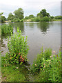
A leaden sky
A leaden sky and growling thunder announce the arrival of a thunderstorm over the River Yare.
Image: © Evelyn Simak
Taken: 15 Jun 2009
0.06 miles

9

A busy bee
The insect is collecting pollen before the thunderstorm arrives. For a wider view of this location see > http://www.geograph.org.uk/photo/1358383.
Image: © Evelyn Simak
Taken: 15 Jun 2009
0.06 miles
10
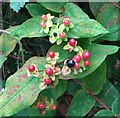
Tutsan (Hypericum androsaemum)
This plant is a relative of St John's wort and native to western and southern Europe and Iran. It can commonly be found growing in damp or shaded habitats including deciduous woodland and hedgerows. When the leaves are crushed, they smell slightly aromatic.
The common name of the plant is derived from "Toutesaine" which means "all healthy" and indeed it was an important medicinal plant in the Middle Ages when it was used for treating a number of diseases including cholera. The Physicians of Myddfai wrote that “The mugwort, madder, meadow sweet, milfoil, hemp, red cabbage, and the tutsan, all these seven herbs enter into the composition of the medicine required. Whosoever obtains them all, will not languish long from a wounded lung, or need fear for his life.” The 19th century herbalist Culpeper recommended it for treating sciatica, gout and for healing burnings by fire.
Image: © Evelyn Simak
Taken: 6 Aug 2017
0.06 miles