IMAGES TAKEN NEAR TO
Vera Road, NORWICH, NR13 6QP
Introduction
This page details the photographs taken nearby to Vera Road, NR13 6QP by members of the Geograph project.
The Geograph project started in 2005 with the aim of publishing, organising and preserving representative images for every square kilometre of Great Britain, Ireland and the Isle of Man.

There are currently over 7.5m images from over14,400 individuals and you can help contribute to the project by visiting https://www.geograph.org.uk
Image Map
Images are licensed for reuse under creativecommons.org/licenses/by-sa/2.0
Notes
- Clicking on the map will re-center to the selected point.
- The higher the marker number, the further away the image location is from the centre of the postcode.
Image Listing (39 Images Found)
Images are licensed for reuse under creativecommons.org/licenses/by-sa/2.0
Image
Details
Distance
1
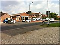
Howes Motor Company
Salhouse Road, Rackheath.
Image: © Dave Fergusson
Taken: 10 Aug 2012
0.13 miles
2
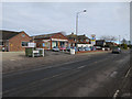
Howes Motor Company
In New Rackheath.
Image: © Hugh Venables
Taken: 28 Feb 2016
0.14 miles
4
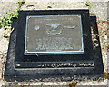
467th Bomb Group memorial plaque
The plaque is located at the foot of the village sign > http://www.geograph.org.uk/photo/4143294 in Salhouse Road. It was dedicated in 1983. See also > http://www.geograph.org.uk/photo/4988296.
Image: © Evelyn Simak
Taken: 9 Jun 2016
0.18 miles
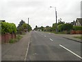
5
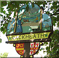
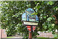
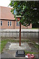
Rackheath village sign
The B-24 Liberator bomber aircraft depicted at left commemorates the village's history when nearby RAF Rackheath was one of the aerodromes used by the United States Army Air Forces (USAAF) during WW2.
Image: © Evelyn Simak
Taken: 29 Aug 2014
0.19 miles
6
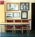
Holy Trinity church - RAF Rackheath museum room
As well as Sunday worship, family communion and Sunday Club, the church > http://www.geograph.org.uk/photo/4143275 is also used for local clubs and activities, for example the Rackheath Youth Club, Parent and Toddler group and the Rackheath WI (Women's Institute). A small museum containing photographs of the nearby Rackheath aerodrome is housed in an adjoining room.
Image: © Evelyn Simak
Taken: 9 Jun 2016
0.19 miles
7
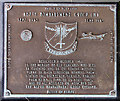
467th Bomb Group memorial plaque
The plaque is located at the foot of the village sign > http://www.geograph.org.uk/photo/4143294 in Salhouse Road. It was dedicated in 1983. See also > http://www.geograph.org.uk/photo/4988290.
Image: © Evelyn Simak
Taken: 9 Jun 2016
0.19 miles
8
Rackheath village sign
In the right corner is a tribute to Rackheath airfield showing a depiction of the control tower and a B 24 Liberator.
Image: © Adrian S Pye
Taken: 25 Jul 2020
0.19 miles
9
Memorial plaque at the foot of Rackheath village sign
The plaque was dedicated 8 October 1983 "to the memory of our comrades who died in training and in 212 combat missions flown in B-24 Liberator Bombers from Station 145, Rackheath, Norfolk, England from April 1944 to 25 April 1945, and to all assigned or attached to the 467th Bombardment Group (Heavy). Battle of Europe. https://www.geograph.org.uk/photo/6549036
Image: © Adrian S Pye
Taken: 25 Jul 2020
0.19 miles
10
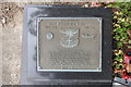
Memorial plaque at the foot of Rackheath village sign
The plaque was dedicated 8 October 1983 "to the memory of our comrades who died in training and in 212 combat missions flown in B-24 Liberator Bombers from Station 145, Rackheath, Norfolk, England from April 1944 to 25 April 1945, and to all assigned or attached to the 467th Bombardment Group (Heavy). Battle of Europe
Image: © Adrian S Pye
Taken: 25 Jul 2020
0.19 miles