IMAGES TAKEN NEAR TO
Beighton Road, NORWICH, NR13 3DD
Introduction
This page details the photographs taken nearby to Beighton Road, NR13 3DD by members of the Geograph project.
The Geograph project started in 2005 with the aim of publishing, organising and preserving representative images for every square kilometre of Great Britain, Ireland and the Isle of Man.

There are currently over 7.5m images from over14,400 individuals and you can help contribute to the project by visiting https://www.geograph.org.uk
Image Map
Images are licensed for reuse under creativecommons.org/licenses/by-sa/2.0
Notes
- Clicking on the map will re-center to the selected point.
- The higher the marker number, the further away the image location is from the centre of the postcode.
Image Listing (6 Images Found)
Images are licensed for reuse under creativecommons.org/licenses/by-sa/2.0
Image
Details
Distance
1
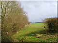
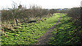
Field alongside the railwayline
The fence marks the edge of the embankment between the field and the Norwich to Great Yarmouth railway line.
Image: © Flo Nettle
Taken: 22 Feb 2007
0.19 miles
3
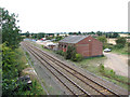
Acle railway station - former goods shed and coal yard
This view was taken from bridge 1286A > http://www.geograph.org.uk/photo/1477386.
Acle railway station > http://www.geograph.org.uk/photo/1477327 was built in 1881 as the datestones > http://www.geograph.org.uk/photo/1477316 on station building and station house indicate. The station was opened by the GER (Great Eastern Railway) and in 1923 became part of the London and North Eastern Railway. On nationalisation in 1948 it passed on to the Eastern Region of British Railways and was later served by regional railways until the privatisation of British railways. Presently Acle is served by National Express East Anglia who operate services between Norwich and Great Yarmouth using diesel multiple units of classes 153, 156 > http://www.geograph.org.uk/photo/1477378 or 170. The station is unmanned. The station house > http://www.geograph.org.uk/photo/1477340 has been converted into a private dwelling and the station building > http://www.geograph.org.uk/photo/1477311 serves as a self-catering holiday cottage. Acle is the only station on this branch of the Wherry Line which has a passing loop > http://www.geograph.org.uk/photo/1477397. At some time in the past it was a coaling depot which was located just west of the former goods shed which still stands.
Image: © Evelyn Simak
Taken: 7 Sep 2009
0.20 miles
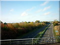
4
Acle railway station - the western end of the loop
Heading for Norwich, the line here passes the former goods shed (seen at right) and adjoining former coal depot. This view was taken from bridge 1286A > http://www.geograph.org.uk/photo/1477386.
Acle railway station > http://www.geograph.org.uk/photo/1477327 was built in 1881 as the datestones > http://www.geograph.org.uk/photo/1477316 on station building and station house indicate. The station was opened by the GER (Great Eastern Railway) and in 1923 became part of the London and North Eastern Railway. On nationalisation in 1948 it passed on to the Eastern Region of British Railways and was later served by regional railways until the privatisation of British railways. Presently Acle is served by National Express East Anglia who operate services between Norwich and Great Yarmouth using diesel multiple units of classes 153, 156 > http://www.geograph.org.uk/photo/1477378 or 170. The station is unmanned. The station house > http://www.geograph.org.uk/photo/1477340 has been converted into a private dwelling and the station building > http://www.geograph.org.uk/photo/1477311 serves as a self-catering holiday cottage. Acle is the only station on this branch of the Wherry Line which has a passing loop. At some time in the past it was a coaling depot which was located just west of the former goods shed > http://www.geograph.org.uk/photo/1477402 which still stands.
Image: © Evelyn Simak
Taken: 7 Sep 2009
0.20 miles
5
Footpath in Jubilee Wood
Followed in this direction it leads onto the A47 road.
Jubilee Wood is a new community wood covering 3.5 hectares (8.7 acres) which was planted by volunteers from Acle and surrounding villages in celebration of the Queen’s Golden Jubilee in 2002. It forms part of a circular walk in the vicinity of Acle and is also part of the Burlingham Woodland Walks. It was planted with species native to the area including pedunculate oak. This reflects the origin of the place name Acle: Old English for oak is ‘ac’ and ‘leah’ is wood. A glade in the centre provides views across Acle and over the marshes beyond and is the location of a sundial and a wildflower meadow.
Image: © Evelyn Simak
Taken: 31 Dec 2015
0.22 miles
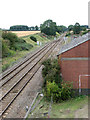
6
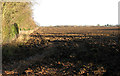
Ploughed field north of Jolly's Lane, Acle
Image: © Evelyn Simak
Taken: 19 Dec 2013
0.24 miles