Acle railway station - the western end of the loop
Introduction
The photograph on this page of Acle railway station - the western end of the loop by Evelyn Simak as part of the Geograph project.
The Geograph project started in 2005 with the aim of publishing, organising and preserving representative images for every square kilometre of Great Britain, Ireland and the Isle of Man.

There are currently over 7.5m images from over 14,400 individuals and you can help contribute to the project by visiting https://www.geograph.org.uk
Acle railway station - the western end of the loop
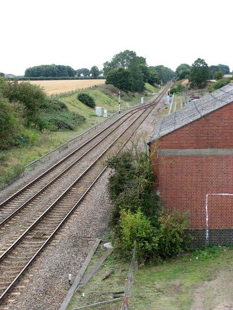
Image: © Evelyn Simak Taken: 7 Sep 2009
Heading for Norwich, the line here passes the former goods shed (seen at right) and adjoining former coal depot. This view was taken from bridge 1286A > http://www.geograph.org.uk/photo/1477386. Acle railway station > http://www.geograph.org.uk/photo/1477327 was built in 1881 as the datestones > http://www.geograph.org.uk/photo/1477316 on station building and station house indicate. The station was opened by the GER (Great Eastern Railway) and in 1923 became part of the London and North Eastern Railway. On nationalisation in 1948 it passed on to the Eastern Region of British Railways and was later served by regional railways until the privatisation of British railways. Presently Acle is served by National Express East Anglia who operate services between Norwich and Great Yarmouth using diesel multiple units of classes 153, 156 > http://www.geograph.org.uk/photo/1477378 or 170. The station is unmanned. The station house > http://www.geograph.org.uk/photo/1477340 has been converted into a private dwelling and the station building > http://www.geograph.org.uk/photo/1477311 serves as a self-catering holiday cottage. Acle is the only station on this branch of the Wherry Line which has a passing loop. At some time in the past it was a coaling depot which was located just west of the former goods shed > http://www.geograph.org.uk/photo/1477402 which still stands.
Images are licensed for reuse under creativecommons.org/licenses/by-sa/2.0
Image Location
Latitude
52.633557
Longitude
1.539389