IMAGES TAKEN NEAR TO
Staithe Road, NORWICH, NR12 9QU
Introduction
This page details the photographs taken nearby to Staithe Road, NR12 9QU by members of the Geograph project.
The Geograph project started in 2005 with the aim of publishing, organising and preserving representative images for every square kilometre of Great Britain, Ireland and the Isle of Man.

There are currently over 7.5m images from over14,400 individuals and you can help contribute to the project by visiting https://www.geograph.org.uk
Image Map
Images are licensed for reuse under creativecommons.org/licenses/by-sa/2.0
Notes
- Clicking on the map will re-center to the selected point.
- The higher the marker number, the further away the image location is from the centre of the postcode.
Image Listing (35 Images Found)
Images are licensed for reuse under creativecommons.org/licenses/by-sa/2.0
Image
Details
Distance
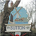
1
Village Sign, Sutton, Norfolk
Close-up of Sutton Village Sign, not far from Staithe Road.
Image: © Christine Matthews
Taken: 24 Sep 2009
0.04 miles
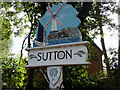
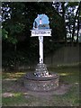
2
Sutton Village Sign, Sutton, Norfolk
At the eastern end of Staithe Road.
Image: © Christine Matthews
Taken: 24 Sep 2009
0.04 miles
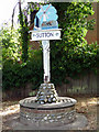
3
Sutton village sign
Sutton sign pays tribute to the Norfolk wherries which were built in the shipyard which once thrived in the village. Navigable cuts were dug to connect Sutton to the River Ant and consequently all the main navigable waterways. The mill is still very much a part of the village being the largest mill in the county standing just under 80 feet (24 metres) tall. It was built in 1789 with 8 floors. In 1861 it caught fire and was rebuilt and another floor added taking it to its current height. https://www.geograph.org.uk/photo/2250801
https://www.geograph.org.uk/photo/6674247
Image: © Adrian S Pye
Taken: 12 Nov 2020
0.05 miles
4
Sutton village sign
Sutton sign pays tribute to the Norfolk wherries which were built in the shipyard which once thrived in the village. Navigable cuts were dug to connect Sutton to the River Ant and consequently all the main navigable waterways. The mill is still very much a part of the village being the largest mill in the county standing just under 80 feet (24 metres) tall. It was built in 1789 with 8 floors. In 1861 it caught fire and was rebuilt and another floor added taking it to its current height. https://www.geograph.org.uk/photo/2250801
https://www.geograph.org.uk/photo/6674250
Image: © Adrian S Pye
Taken: 12 Nov 2020
0.05 miles
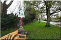
5
Village Sign, Sutton
Image: © Katy Walters
Taken: 4 Jul 2006
0.06 miles
6
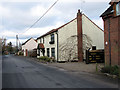
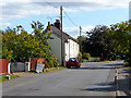
Cottages on Old Yarmouth Road
Old Yarmouth Road is the main thoroughfare through the village of Sutton. This view was taken in northerly direction.
Image: © Evelyn Simak
Taken: 7 Feb 2009
0.08 miles
7
Staithe Road, Sutton, Norfolk
As seen from the junction with the Old Yarmouth Road.
Image: © Christine Matthews
Taken: 24 Sep 2009
0.11 miles
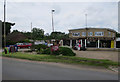
8
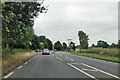
A149, Sutton
Heading towards Great Yarmouth. Here bypassing Sutton, following the course of the Midland and Great Northern Joint Railway, which closed here in 1959. The road to Sutton Staithe, which is to the right, crosses ahead.
Image: © Robin Webster
Taken: 14 Aug 2018
0.11 miles
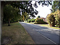
9
Old Yarmouth Road, Sutton, Norfolk
As seen from close to the junction with Staithe Road.
Image: © Christine Matthews
Taken: 24 Sep 2009
0.12 miles