IMAGES TAKEN NEAR TO
NR12 8HZ
Introduction
This page details the photographs taken nearby to NR12 8HZ by members of the Geograph project.
The Geograph project started in 2005 with the aim of publishing, organising and preserving representative images for every square kilometre of Great Britain, Ireland and the Isle of Man.

There are currently over 7.5m images from over14,400 individuals and you can help contribute to the project by visiting https://www.geograph.org.uk
Image Map
Images are licensed for reuse under creativecommons.org/licenses/by-sa/2.0
Notes
- Clicking on the map will re-center to the selected point.
- The higher the marker number, the further away the image location is from the centre of the postcode.
Image Listing (5 Images Found)
Images are licensed for reuse under creativecommons.org/licenses/by-sa/2.0
Image
Details
Distance
1
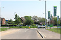
New roundabout in Hoveton
The roundabout was built in conjunction with an expansive new housing development which covers the former agricultural land to the west of the A1151 road > http://www.geograph.org.uk/photo/2880160. A great number of houses have already been built and many of these are now occupied but construction work is still ongoing > http://www.geograph.org.uk/photo/3956415 - http://www.geograph.org.uk/photo/3956420. Neither the roundabout nor the houses are marked on current maps nor can they to date be seen in aerial views.
Image: © Evelyn Simak
Taken: 30 Apr 2014
0.19 miles
2

Old Milestone by the A1151, Stalham Road, Hoveton parish
Stone post by the A1151, in parish of Hoveton (North Norfolk District), 20yds North of surgery, on open verge above ditch.
Inscription once read:-
(Norwich)
(8)
Surveyed but lost 2013
Milestone Society National ID: NO_NWR8
Image: © Milestone Society
Taken: Unknown
0.21 miles


5
Land Acquired Sign Beside A1151, Hoveton, Norfolk.
This view will change greatly to a backdrop of houses. The position of the sign has been recorded as a reference point (GPS) for any subsequent then and now pictures.
Image: © Kevin Thomas
Taken: 3 Mar 2012
0.22 miles