IMAGES TAKEN NEAR TO
Tuttington, NORWICH, NR11 6TL
Introduction
This page details the photographs taken nearby to NR11 6TL by members of the Geograph project.
The Geograph project started in 2005 with the aim of publishing, organising and preserving representative images for every square kilometre of Great Britain, Ireland and the Isle of Man.

There are currently over 7.5m images from over14,400 individuals and you can help contribute to the project by visiting https://www.geograph.org.uk
Image Map
Images are licensed for reuse under creativecommons.org/licenses/by-sa/2.0
Notes
- Clicking on the map will re-center to the selected point.
- The higher the marker number, the further away the image location is from the centre of the postcode.
Image Listing (26 Images Found)
Images are licensed for reuse under creativecommons.org/licenses/by-sa/2.0
Image
Details
Distance
3
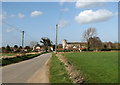
View south along Norwich Road
On a stormy day.
Image: © Evelyn Simak
Taken: 12 Mar 2008
0.15 miles
4
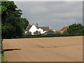
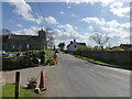
Approach to Tuttington from the south
The church of St Peter & St Paul can be seen in the background (at right).
Image: © Evelyn Simak
Taken: 12 Mar 2008
0.16 miles
5
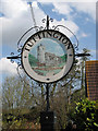
Tuttington village sign
The village sign depicts the church of St Peter & St Paul.
Image: © Evelyn Simak
Taken: 31 Mar 2008
0.18 miles
6
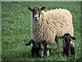
Well looked-after
These lambs chose a particularly stormy day to come into this world but with a bellyful of milk they are well able to withstand the blustery weather.
Image: © Evelyn Simak
Taken: 12 Mar 2008
0.19 miles
7
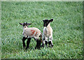
Nos. 30 and 31
Marking new-born lambs, by spraying consecutive numbers onto their coats with a special paint, in the order they are born, helps the farmer to keep track.
Image: © Evelyn Simak
Taken: 12 Mar 2008
0.20 miles
8
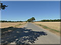
Towards Tuttington on rural Norwich Road
Image: © David Pashley
Taken: 10 Aug 2022
0.21 miles
10
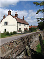
The Old Post Office
On Norwich Road, opposite the church of SS Peter and Paul > http://www.geograph.org.uk/photo/861761. The view was taken from the churchyard. The cottage dates from c. 1725; it used to be a public house and became a Post Office in 1883. It is now a private dwelling house. This information was obtained from a leaflet that is available - in context with a wall hanging > http://www.geograph.org.uk/photo/861810 made by ladies of the village - in the church of SS Peter and Paul. There no longer is a post office in the village of Tuttington.
Image: © Evelyn Simak
Taken: 26 Jun 2008
0.22 miles