IMAGES TAKEN NEAR TO
The Meadows, NORWICH, NR11 6HP
Introduction
This page details the photographs taken nearby to The Meadows, NR11 6HP by members of the Geograph project.
The Geograph project started in 2005 with the aim of publishing, organising and preserving representative images for every square kilometre of Great Britain, Ireland and the Isle of Man.

There are currently over 7.5m images from over14,400 individuals and you can help contribute to the project by visiting https://www.geograph.org.uk
Image Map
Images are licensed for reuse under creativecommons.org/licenses/by-sa/2.0
Notes
- Clicking on the map will re-center to the selected point.
- The higher the marker number, the further away the image location is from the centre of the postcode.
Image Listing (100 Images Found)
Images are licensed for reuse under creativecommons.org/licenses/by-sa/2.0
Image
Details
Distance

2

St Michael's Church, Aylsham
From one direction, this mediaeval church dominates the market place, from others it rises above trees and fields
Image: © Gareth Hughes
Taken: Unknown
0.05 miles
3

Snowy roofscape of Red Lion Street
The results of a rare 2020 snowfall courtesy of Storm Ciara. These rooftops are the backs of some buildings on Red Lion Street, close to Image
Image: © Zorba the Geek
Taken: 10 Feb 2020
0.05 miles
4

Pasture adjoining the Weavers Way
Houses on the northern edge of Aylsham can be seen in the background.
Image: © Evelyn Simak
Taken: 6 May 2009
0.07 miles
5

Footpath to Aylsham
This kissing gate stands at the start of a public footpath which turns off the Weavers Way long distance footpath and leads to Aylsham.
Image: © Evelyn Simak
Taken: 6 May 2009
0.10 miles
6
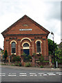
The Tabernacle
On Gashouse Hill - a Wesleyan chapel built in 1868. Established over 150 years ago as 'Aylsham Tabernacle' the ACC (Aylsham Community Church) was part of the circuit of Wesleyan Reform Union churches; in the 1980s the church joined with Newfrontiers. The building has since been converted into a private dwelling house.
Image: © Evelyn Simak
Taken: 13 Jul 2008
0.13 miles
7

View through a bridge
This bridge spanning the Weavers Way long distance footpath carries Cromer Road over it. See also > http://www.geograph.org.uk/photo/1290696. The path here follows a dismantled railway line which was operated by the Midland and Great Northern Joint Railway line, linking the Midlands with the Norfolk Coast. Opened by the Eastern and Midlands Railway, it became the Midland and Great Northern Joint Railway, and was later converted to a joint operation of the London, Midland and Scottish Railway, with the London and North Eastern Railway taking sole operation in 1936. The line was closed in 1959.
Image: © Evelyn Simak
Taken: 6 May 2009
0.13 miles
8
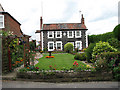
Pretty pebble flint cottages
Numbers 3 and 5, Millgate - a pair of early 19th century cottages. Flint pebbles were used for the frontage and for creating a decorative centre panel depicting a curving swastika design.
Not having experienced any disastrous 17th or 18th century fires, the medieval street pattern and many or the houses in the historical core of Aylsham have survived and there are 240 listed buildings here (accounting for 20% of all listed buildings in the district of Broadland). The Millgate area to the northeast of the town, however, was developed during the late 18th century, when the completion of the Bure navigation canal (Aylsham Navigation) brought further wealth to the town. One of the important features of Aylsham houses (and buildings in surrounding parishes) is the use of bricks for building, influenced by the nearby Blickling Hall. The development of Flemish bond brickwork and Dutch shaped gables influenced builders in the area and a cluster of early to mid 17th century brick buildings can be found within a five mile radius around Blickling, in an area where flint was the commonly used building material.
Image: © Evelyn Simak
Taken: 13 Jul 2008
0.13 miles
9

Public footpath connecting with Cromer Road
Image: © Evelyn Simak
Taken: 13 Jul 2008
0.13 miles