IMAGES TAKEN NEAR TO
Salle, NORWICH, NR10 4SF
Introduction
This page details the photographs taken nearby to NR10 4SF by members of the Geograph project.
The Geograph project started in 2005 with the aim of publishing, organising and preserving representative images for every square kilometre of Great Britain, Ireland and the Isle of Man.

There are currently over 7.5m images from over14,400 individuals and you can help contribute to the project by visiting https://www.geograph.org.uk
Image Map
Images are licensed for reuse under creativecommons.org/licenses/by-sa/2.0
Notes
- Clicking on the map will re-center to the selected point.
- The higher the marker number, the further away the image location is from the centre of the postcode.
Image Listing (7 Images Found)
Images are licensed for reuse under creativecommons.org/licenses/by-sa/2.0
Image
Details
Distance
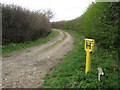
1
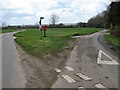
Junction near Manor Farm
Heading past > Image in southerly direction. The road turning off at left connects with the B1149 (Holt Road) further to the east. See also > Image for a view of this junction viewed from the opposite direction.
Image: © Evelyn Simak
Taken: 8 Apr 2008
0.02 miles
3
Postbox beside junction
The lane turning off in easterly direction (at right) connects with the B1149 (Holt Road); the road heading north leads to Heydon.
Image: © Evelyn Simak
Taken: 8 Apr 2008
0.04 miles
5
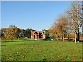
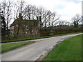
Stinton Hall at Stinton Hall Farm, Salle
Image: © Adrian S Pye
Taken: 6 Nov 2017
0.19 miles
6
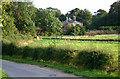
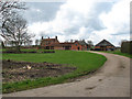
Stintonhall Farm, Salle
Stintonhall Farm in the village of Salle from the Heydon-Salle road.
Image: © Jurek and Trish Sienkiewicz
Taken: 30 Sep 2006
0.19 miles