IMAGES TAKEN NEAR TO
Ivy Road, NORWICH, NR10 3PX
Introduction
This page details the photographs taken nearby to Ivy Road, NR10 3PX by members of the Geograph project.
The Geograph project started in 2005 with the aim of publishing, organising and preserving representative images for every square kilometre of Great Britain, Ireland and the Isle of Man.

There are currently over 7.5m images from over14,400 individuals and you can help contribute to the project by visiting https://www.geograph.org.uk
Image Map
Images are licensed for reuse under creativecommons.org/licenses/by-sa/2.0
Notes
- Clicking on the map will re-center to the selected point.
- The higher the marker number, the further away the image location is from the centre of the postcode.
Image Listing (5 Images Found)
Images are licensed for reuse under creativecommons.org/licenses/by-sa/2.0
Image
Details
Distance
1
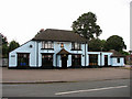
The Longe Arms
The Longe Arms is located near the junction of Crostwick Lane with Buxton Road.
Image: © Evelyn Simak
Taken: 17 Sep 2007
0.14 miles
2
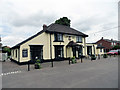
The Longe Arms Spixworth
Located on the junction of Buxton Road and Crostwick Lane. It nearly closed at the end of 2010 when the lease was due to run out. Two villagers decided to take it over rather than see it close.
Image: © Phil Gaskin
Taken: 25 Jun 2012
0.18 miles
3
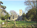
Spixworth St Peter's church
The very slender rectangular tower without buttresses at the extreme southwest corner of the south aisle is most disorientating. Entry is through the west doorway. Inside you will find a 12th century round Caen stone font which is squared at the base.
Image: © Adrian S Pye
Taken: 10 May 2009
0.24 miles
4
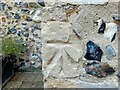
OS Benchmark
Recorded on Benchmark Database as 'Spixworth, St Peter's Church'.
Image: © David Bremner
Taken: 28 Sep 2023
0.25 miles
5
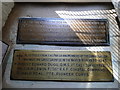
Spixworth War Memorial brasses
The brasses are affixed to a window sill on the south side of the chancel.
Image: © Adrian S Pye
Taken: 5 Aug 2015
0.25 miles