IMAGES TAKEN NEAR TO
Spixworth Road, NORWICH, NR10 3JB
Introduction
This page details the photographs taken nearby to Spixworth Road, NR10 3JB by members of the Geograph project.
The Geograph project started in 2005 with the aim of publishing, organising and preserving representative images for every square kilometre of Great Britain, Ireland and the Isle of Man.

There are currently over 7.5m images from over14,400 individuals and you can help contribute to the project by visiting https://www.geograph.org.uk
Image Map
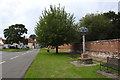
Images are licensed for reuse under creativecommons.org/licenses/by-sa/2.0
Notes
- Clicking on the map will re-center to the selected point.
- The higher the marker number, the further away the image location is from the centre of the postcode.
Image Listing (92 Images Found)
Images are licensed for reuse under creativecommons.org/licenses/by-sa/2.0
Image
Details
Distance
1
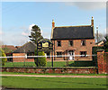
Elm Farm Country House
A restaurant and bed & breakfast establishment in Norwich Road.
Horsham and Newton St Faith are situated about 6 miles north of Norwich. The church of SS Mary and Andrew > http://www.geograph.org.uk/photo/1191886 located in the grounds of a ruined 13th century priory, serves both Church of England and Methodist worshippers. There are two Post Offices (one serving each village), one restaurant and two public hostelries. For more information and old photographs see http://www.st-faith.co.uk/
Image: © Evelyn Simak
Taken: 5 Mar 2009
0.06 miles
2
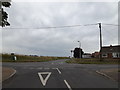
Old Norwich Road, Horsham St.Faith
At the junction with Crown Road
Image: © Geographer
Taken: 2 Jul 2015
0.07 miles
3
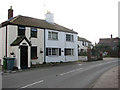
Cottages on Norwich Road
Horsham and Newton St Faith are situated about 6 miles north of Norwich. The church of SS Mary and Andrew > http://www.geograph.org.uk/photo/1191886 located in the grounds of a ruined 13th century priory, serves both Church of England and Methodist worshippers. There are two Post Offices (one serving each village), one restaurant and two public hostelries. For more information and old photographs see http://www.st-faith.co.uk/
Image: © Evelyn Simak
Taken: 5 Mar 2009
0.07 miles
4
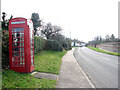
Old red telephone box
This view was taken along Norwich Road in southerly direction. The brick and flint wall seen at right surrounds the 13th century priory grounds.
Horsham and Newton St Faith are situated about 6 miles north of Norwich. The church of SS Mary and Andrew > http://www.geograph.org.uk/photo/1191886 located in the grounds of a ruined 13th century priory, serves both Church of England and Methodist worshippers. There are two Post Offices (one serving each village), one restaurant and two public hostelries. For more information and old photographs see http://www.st-faith.co.uk/
Image: © Evelyn Simak
Taken: 5 Mar 2009
0.08 miles
5
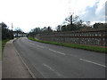
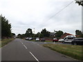
View south along Norwich Road
The brick and flint wall seen at right surrounds the ruined 13th century priory grounds.
Horsham and Newton St Faith are situated about 6 miles north of Norwich. The church of SS Mary and Andrew > http://www.geograph.org.uk/photo/1191886 located in the grounds of a ruined 13th century priory, serves both Church of England and Methodist worshippers. There are two Post Offices (one serving each village), one restaurant and two public hostelries. For more information and old photographs see http://www.st-faith.co.uk/
Image: © Evelyn Simak
Taken: 5 Mar 2009
0.08 miles
6
Old Norwich Road, Horsham St.Faith
At the junction with Norwich Road & Church Street
Image: © Geographer
Taken: 2 Jul 2015
0.08 miles
7
Horsham St. Faith village sign
Street view: https://www.geograph.org.uk/photo/6591234
North face: https://www.geograph.org.uk/photo/6591236
Image: © Adrian S Pye
Taken: 4 Sep 2020
0.08 miles
8
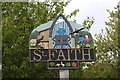
Horsham St. Faith village sign
Street view: https://www.geograph.org.uk/photo/6591234
South Face https://www.geograph.org.uk/photo/6591245
Image: © Adrian S Pye
Taken: 4 Sep 2020
0.08 miles
9
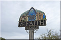
Horsham St. Faith village sign
The sign is double sided
North facing https://www.geograph.org.uk/photo/6591236
South facing https://www.geograph.org.uk/photo/6591245
In the centre of the signs is St Faith who was tortured to death over a burning brazier. The neatherd herding the oxen represents the cattle fair which used to be held annually in October. The monks belong to the Benedictine priory founded in honour of St. Faith, which once stood in the parish.
The reverse shows a mediaeval scene with a man working his loom of which at one time was a major industry contracted out from Norwich. The children looking at the aircraft represent the post WW 2 generation and RAF Horsham St Faiths which has since transformed into Norwich International Airport.
https://www.geograph.org.uk/photo/4592110
Image: © Adrian S Pye
Taken: 4 Sep 2020
0.08 miles
10
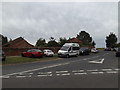
Norwich Road, Horsham St.Faith
At the junction with Old Norwich Road & Church Street
Image: © Geographer
Taken: 2 Jul 2015
0.09 miles