IMAGES TAKEN NEAR TO
NP9 3LN
Introduction
This page details the photographs taken nearby to NP9 3LN by members of the Geograph project.
The Geograph project started in 2005 with the aim of publishing, organising and preserving representative images for every square kilometre of Great Britain, Ireland and the Isle of Man.

There are currently over 7.5m images from over14,400 individuals and you can help contribute to the project by visiting https://www.geograph.org.uk
Image Map
Images are licensed for reuse under creativecommons.org/licenses/by-sa/2.0
Notes
- Clicking on the map will re-center to the selected point.
- The higher the marker number, the further away the image location is from the centre of the postcode.
Image Listing (223 Images Found)
Images are licensed for reuse under creativecommons.org/licenses/by-sa/2.0
Image
Details
Distance
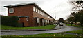
1
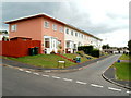
Maugham Close, Gaer, Newport
Viewed across Morton Way. There are 7 houses on Maugham Close, all on one side of the street. The houses face the rear of Shakespeare Crescent houses.
Image: © Jaggery
Taken: 19 Jul 2011
0.00 miles
2
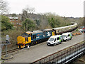
The South Wales Explorer railtour at Park Junction
Vintage Trains' South Wales Explorer railtour featured diesel class 37 No. 37403 and class 20 No. 20189 locomotives in top-and-tail formation. The tour originated at Dorridge and visited Cardiff Central via reversal at Park Junction, an empty stock move to Pengam Sidings and then Cardiff to Cwmbargoed, returning to Ninian Park and then back to Dorridge.
In this view, No. 37403 is in the lead on the approach to Park Junction near Newport.
Image: © Gareth James
Taken: 11 Mar 2023
0.06 miles
3
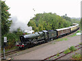
Railtour at Park Junction
Ex-Western Region 4-6-0 No. 7029 Clun Castle approaches Park Junction, Newport on with Vintage Trains' Return to Steam railtour. The train is turning here and will proceed diesel-hauled to Cardiff before returning to Tyseley.
Image: © Gareth James
Taken: 2 Oct 2021
0.06 miles
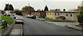
4
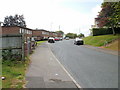
Shakespeare Crescent, Gaer, Newport
Heading away from Masefield Vale and Gaer Baptist church towards the Morton Way junction.
Image: © Jaggery
Taken: 1 Oct 2009
0.06 miles
5
Jane Austen Close, Gaer, Newport
Housing on the north side of Jane Austen Close. There are no houses on the other side of the close.
Image: © Jaggery
Taken: 12 Nov 2009
0.06 miles
6
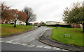
Ruskin Rise, Gaer, Newport
Ruskin Rise climbs away from Shakespeare Crescent.
Image: © Jaggery
Taken: 12 Nov 2009
0.06 miles
7
Jane Austen Close, Gaer, Newport
The view west from Morton Way. Jane Austen Close is a row of ten houses, all on one side of the street.
Image: © Jaggery
Taken: 19 Jul 2011
0.06 miles
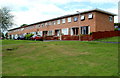
8
Priestley Close, Gaer, Newport
Viewed across Morton Way. There are 7 houses on Priestley Close, a short cul-de-sac. In common with several nearby streets, the houses are all on one side of the road. The other side is the rear of properties in the next street, Maugham Close.
Image: © Jaggery
Taken: 19 Jul 2011
0.06 miles
9
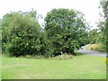
Contaminated water - keep clear, Masefield Vale, Gaer, Newport
Viewed from the corner of Shakespeare Crescent. At first glance, the trees on the side of Masefield Vale suggest a pleasant 'green lung' in the middle of the Gaer housing estate. But a notice warns
CONTAMINATED WATER - KEEP CLEAR. The water is in a small brook, shown on the Ordnance Survey map as an 'issue', draining the higher ground on the west side of Masefield Vale. I do not know when or how the water was contaminated.
Image: © Jaggery
Taken: 19 Jul 2011
0.06 miles
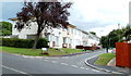
10
Shakespeare Crescent, Gaer, Newport
Along this part of Shakespeare Crescent, close to Park Junction http://www.geograph.org.uk/photo/1579956 the bases of the houses on the south side are below street level.
Image: © Jaggery
Taken: 12 Nov 2009
0.06 miles