IMAGES TAKEN NEAR TO
Llanbedr, CRICKHOWELL, NP8 1TA
Introduction
This page details the photographs taken nearby to NP8 1TA by members of the Geograph project.
The Geograph project started in 2005 with the aim of publishing, organising and preserving representative images for every square kilometre of Great Britain, Ireland and the Isle of Man.

There are currently over 7.5m images from over14,400 individuals and you can help contribute to the project by visiting https://www.geograph.org.uk
Image Map
Images are licensed for reuse under creativecommons.org/licenses/by-sa/2.0
Notes
- Clicking on the map will re-center to the selected point.
- The higher the marker number, the further away the image location is from the centre of the postcode.
Image Listing (8 Images Found)
Images are licensed for reuse under creativecommons.org/licenses/by-sa/2.0
Image
Details
Distance
1
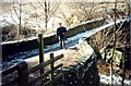
Pont Ucha'r Cwm / Upper Cwm Bridge
Cerddwyr ar Bont Ucha'r Cwm yn Llanbedr Ystrad Yw.
Walker on Upper Cwm Bridge at Llanbedr [Ystrad Yw](trans. St Peters' Church in the vale of yews).
Image: © Alan Richards
Taken: 8 Feb 1996
0.15 miles
2
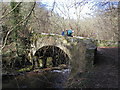
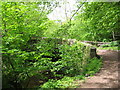
Upper Cwm Bridge, Llanbedr
For a similar view in summertime see Image]
Image: © John Brightley
Taken: 15 Feb 2004
0.16 miles
4
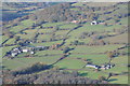
Farmland near Llanbedr
Farmland near Llanbedr viewed from the western slopes of Sugar Loaf.
Image: © Philip Halling
Taken: 23 Nov 2013
0.18 miles

6
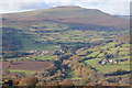
View over Llanbedr
View over Llanbedr with Pen Cerrig-calch above. Viewed from the western slopes of Sugar Loaf.
Image: © Philip Halling
Taken: 23 Nov 2013
0.20 miles
7
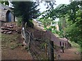
House alongside Grwyne Fawr
A house located above the banks of the Grwyne Fawr.
Image: © Alan Hughes
Taken: 2 Aug 2018
0.24 miles
