IMAGES TAKEN NEAR TO
Felindre Terrace, CRICKHOWELL, NP8 1RR
Introduction
This page details the photographs taken nearby to Felindre Terrace, NP8 1RR by members of the Geograph project.
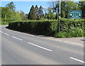
The Geograph project started in 2005 with the aim of publishing, organising and preserving representative images for every square kilometre of Great Britain, Ireland and the Isle of Man.

There are currently over 7.5m images from over14,400 individuals and you can help contribute to the project by visiting https://www.geograph.org.uk
Image Map
Images are licensed for reuse under creativecommons.org/licenses/by-sa/2.0
Notes
- Clicking on the map will re-center to the selected point.
- The higher the marker number, the further away the image location is from the centre of the postcode.
Image Listing (34 Images Found)
Images are licensed for reuse under creativecommons.org/licenses/by-sa/2.0
Image
Details
Distance
1
A479 Approaching Cwmdu
Cwmdu or Llanfihangel Cwmdu is a small village situated in the heart of the Black Mountains in Powys. Its name is derived from the Welsh language "Cwm Du", which means 'Black Valley'. It is located on the A479 Talgarth to Tretower road.
Image: © David Dixon
Taken: 14 Apr 2016
0.01 miles
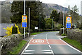
2
From 50 to 40 at the southern edge of Cwmdu, Powys
The 50mph speed limit on the A479 from Tretower drops to 40mph at the edge of Cwmdu.
The blue part of each sign shows POLICE - Speed check area and the Welsh equivalent.
A dark green telecoms cabinet is on the left.
Image: © Jaggery
Taken: 13 May 2018
0.01 miles
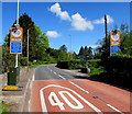
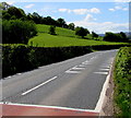
3
From 40 to 50 on the A479, Cwmdu, Powys
Beyond the southern edge of the village, the 40mph speed limit increases to 50mph.
Ahead for Tretower and Crickhowell. A dark green telecoms cabinet is on the right.
Image: © Jaggery
Taken: 13 May 2018
0.01 miles
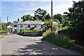
4
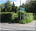
Stile in a gap in a hedge, Cwmdu, Powys
Near the corner of a minor road, the stile is on the east side of the A479, the main road through Cwmdu.
Image: © Jaggery
Taken: 13 May 2018
0.01 miles
5
Cwmdu Campsite & Cottages direction sign, Cwmdu, Powys
Facing traffic on the A479, the main road through Cwmdu.
Image: © Jaggery
Taken: 13 May 2018
0.01 miles
6
Unsuitable route for HGVs, Cwmdu, Powys
The blue signs face the A479, the main road through the village of Cwmdu, alongside the road descending to the hamlet of Felindre and a river named Rhiangoll. The river bridge ahead has a 6' 0" width limit.
Image: © Jaggery
Taken: 13 May 2018
0.02 miles
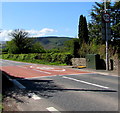
7
Crocodile teeth markings on the A479 on the southern approach to Cwmdu, Powys
Painted white triangles resembling crocodile teeth draw attention to the lower speed limit https://www.geograph.org.uk/photo/5774437 behind the camera. The A479 is the main road through Cwmdu.
Image: © Jaggery
Taken: 13 May 2018
0.03 miles
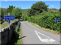
9
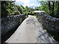
Road from Felindre towards Cwmdu, Powys
The road crosses this https://www.geograph.org.uk/photo/5788454 stone bridge over Rhiangoll, a tributary of the River Usk.
Yr Hen Ysgol https://www.geograph.org.uk/photo/5788423 is ahead on the right.
Image: © Jaggery
Taken: 13 May 2018
0.04 miles
10
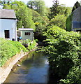
Upstream along Rhiangoll, Felindre, Powys
A tributary of the River Usk, Rhiangoll flows towards the camera on this https://www.geograph.org.uk/photo/5788454 bridge.
Image: © Jaggery
Taken: 13 May 2018
0.05 miles