IMAGES TAKEN NEAR TO
Penmyarth, CRICKHOWELL, NP8 1RN
Introduction
This page details the photographs taken nearby to NP8 1RN by members of the Geograph project.
The Geograph project started in 2005 with the aim of publishing, organising and preserving representative images for every square kilometre of Great Britain, Ireland and the Isle of Man.

There are currently over 7.5m images from over14,400 individuals and you can help contribute to the project by visiting https://www.geograph.org.uk
Image Map
Images are licensed for reuse under creativecommons.org/licenses/by-sa/2.0
Notes
- Clicking on the map will re-center to the selected point.
- The higher the marker number, the further away the image location is from the centre of the postcode.
Image Listing (5 Images Found)
Images are licensed for reuse under creativecommons.org/licenses/by-sa/2.0
Image
Details
Distance
1
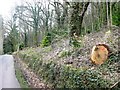
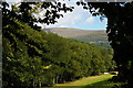
South of Myarth woods
A minor road runs along the southern edge of the woods, dipping in and out of the grid square. This is just within.
Image: © Graham Horn
Taken: 22 Mar 2008
0.13 miles
2
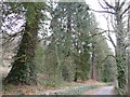
Magnificent redwoods
Lining the north side of Gliffaes road on the edge of Myarth Wood.
Image: © Jonathan Billinger
Taken: 22 Mar 2008
0.16 miles
5
Glanusk estate: looking northeastwards from Bridge 125 on the Monmouthshire and Brecon Canal
Image: © Christopher Hilton
Taken: 28 Aug 2010
0.22 miles