IMAGES TAKEN NEAR TO
Clos Pontganol, CRICKHOWELL, NP8 1NJ
Introduction
This page details the photographs taken nearby to Clos Pontganol, NP8 1NJ by members of the Geograph project.
The Geograph project started in 2005 with the aim of publishing, organising and preserving representative images for every square kilometre of Great Britain, Ireland and the Isle of Man.

There are currently over 7.5m images from over14,400 individuals and you can help contribute to the project by visiting https://www.geograph.org.uk
Image Map
Images are licensed for reuse under creativecommons.org/licenses/by-sa/2.0
Notes
- Clicking on the map will re-center to the selected point.
- The higher the marker number, the further away the image location is from the centre of the postcode.
Image Listing (46 Images Found)
Images are licensed for reuse under creativecommons.org/licenses/by-sa/2.0
Image
Details
Distance
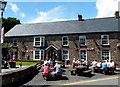
1
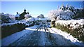
Llangynidr
Approaching the village from the north, having driven as close as the roads would allow. Very attractive Usk Valley village.
Image: © Richard Webb
Taken: Unknown
0.02 miles
2
Distances from crossroads in Llangynidr
Located near the Red Lion. http://www.geograph.org.uk/photo/4109739
Left for Dyffyrn Crawnon (4 miles), right for Brecon (10 miles).
Image: © Jaggery
Taken: 17 Jun 2012
0.04 miles
3
Distances from Llangynidr Village Hall
The signs are alongside the B4558 at the Duffryn Road junction. The village hall http://www.geograph.org.uk/photo/4103047 is on the left.
Left on the B4558 for Talybont on Usk (4 miles) and Brecon (10)
Right on the B4558 for Crickhowell (4) and Gilwern (8).
Image: © Jaggery
Taken: 17 Jun 2012
0.05 miles
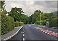
4
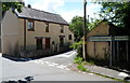
Duffryn Road houses near the Red Lion pub in Llangynidr
The pub http://www.geograph.org.uk/photo/4109739 is just out of shot around the corner.
Image: © Jaggery
Taken: 17 Jun 2012
0.05 miles
5
Outside the Red Lion in Llangynidr
Most of the picnic tables outside the Duffryn Road pub are occupied on a warm sunny day in June 2012.
Image: © Jaggery
Taken: 17 Jun 2012
0.06 miles
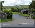
7
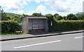
Bus shelter frame, Llangynidr
The shelter is opposite the entrance to the village hall. http://www.geograph.org.uk/photo/4103047
It's likely that the frame has been installed to support a weak roof, or to reinforce the whole structure.
Image: © Jaggery
Taken: 17 Jun 2012
0.07 miles
8
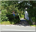
Unsuitable route, Llangynidr
Viewed across the B4558. Vegetation partly hides the message on the blue sign at the edge of Cyffredyn Lane. Visible words are 'Unsuitable for' and 'vehicles'. The hidden word or words could show that the lane is unsuitable for long vehicles, wide vehicles, heavy goods vehicles or some combination of these.
Image: © Jaggery
Taken: 17 Jun 2012
0.07 miles
9
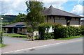
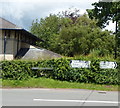
Llangynidr Village Hall
The large, modern village hall is alongside the B4558 Cwm Crawnon Road.
Image: © Jaggery
Taken: 17 Jun 2012
0.07 miles
10
St Cynidr Stone, Llangynidr
Located at the entrance to the village hall. http://www.geograph.org.uk/photo/4103047
The text on the brown tablet on the stone is in Welsh and English. The English is:
ST CYNIDR STONE
ERECTED IN THE YEAR A.D.2000
TO CELEBRATE THE MILLENNIUM
WE ACKNOWLEDGE THE PAST WITH PRIDE
WE APPRECIATE THE PRESENT WITH JOY
WE ANTICIPATE THE FUTURE WITH HOPE
Llangynidr is named after Cynidr, a 6th century Welsh saint.
Image: © Jaggery
Taken: 17 Jun 2012
0.07 miles