IMAGES TAKEN NEAR TO
Orchard Lane, CRICKHOWELL, NP8 1NB
Introduction
This page details the photographs taken nearby to Orchard Lane, NP8 1NB by members of the Geograph project.
The Geograph project started in 2005 with the aim of publishing, organising and preserving representative images for every square kilometre of Great Britain, Ireland and the Isle of Man.

There are currently over 7.5m images from over14,400 individuals and you can help contribute to the project by visiting https://www.geograph.org.uk
Image Map (Loading...)


Getting Data...Please wait
Leaflet Map data © OpenStreetMap
Images are licensed for reuse under creativecommons.org/licenses/by-sa/2.0
Notes
- Clicking on the map will re-center to the selected point.
- The higher the marker number, the further away the image location is from the centre of the postcode.
Image Listing (137 Images Found)
Images are licensed for reuse under creativecommons.org/licenses/by-sa/2.0
Image
Details
Distance
1
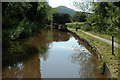
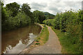
The Monmouthshire and Brecon Canal and Tor y Foel
Narrowboats moored on the Monmouthshire and Brecon Canal at Llangynidr, Tor y Foel can be seen in the background.
Image: © Philip Halling
Taken: 23 May 2009
0.03 miles
2
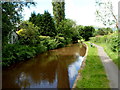
Canal west of bridge 131 in Llangynidr
The Monmouthshire & Brecon Canal viewed from this http://www.geograph.org.uk/photo/3734976 bridge.
Image: © Jaggery
Taken: 17 Jun 2012
0.04 miles
3
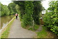
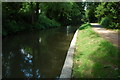
Towpath at Llangynidr
Pedestrian access to Orchard Lane leaves the towpath (carrying Llangynidr footpath 47/1, the Usk Valley Walk and the Beacons Way) of the Monmouthshire and Brecon Canal.
Image: © Derek Harper
Taken: 24 Jun 2021
0.04 miles
4
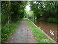
Part of the canal towpath near Llangynidr
The canal towpath here passes between fields and woods and is busy with birds, water birds and wildlife. I looked out for Kingfishers but although I heard them I didn't see them in flight.
Image: © Jeremy Bolwell
Taken: 28 May 2011
0.04 miles
5
Monmouthshire and Brecon Canal at Llangynidr
Looking west from beside bridge 131. The towpath is followed by Llangynidr footpath 47/1, the Usk Valley Walk and the Beacons Way.
Image: © Derek Harper
Taken: 24 Jun 2021
0.05 miles
6
Blaen-y-myarth houses in Llangynidr
Blaen-y-myarth is a cul-de-sac on the west side of the B4560 Forge Road.
Viewed from a path alongside the Monmouthshire & Brecon Canal.
Image: © Jaggery
Taken: 17 Jun 2012
0.06 miles
7
Brecon and Monmouthshire Canal
The Brecon and Monmouthshire Canal at Llangynidr. The canal briefly enters this grid square.
Image: © Philip Halling
Taken: 20 Jun 2009
0.06 miles
8
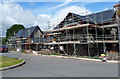
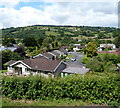
Swedish energy saving houses being built in Llangynidr
Viewed from Coed yr Ynys Road in June 2012.
A nearby board shows Scandia Swedish energy saving homes.
Image: © Jaggery
Taken: 17 Jun 2012
0.07 miles
9
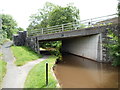
Canal bridge 131, Llangynidr
The bridge carries the B4560 Forge Road over the Monmouthshire & Brecon Canal.
Image: © Jaggery
Taken: 17 Jun 2012
0.08 miles
10
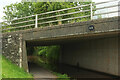
Bridge 131, Monmouthshire and Brecon Canal
Looking the other way from Image The bridge carries the B4560, and the Beacons Way leaves the towpath here to follow the B road northwards. Llangynidr footpath 47/1 and the Usk Valley Walk continue along the towpath beneath the bridge.
Image: © Derek Harper
Taken: 24 Jun 2021
0.08 miles