IMAGES TAKEN NEAR TO
Llangattock, CRICKHOWELL, NP8 1HW
Introduction
This page details the photographs taken nearby to NP8 1HW by members of the Geograph project.
The Geograph project started in 2005 with the aim of publishing, organising and preserving representative images for every square kilometre of Great Britain, Ireland and the Isle of Man.

There are currently over 7.5m images from over14,400 individuals and you can help contribute to the project by visiting https://www.geograph.org.uk
Image Map
Images are licensed for reuse under creativecommons.org/licenses/by-sa/2.0
Notes
- Clicking on the map will re-center to the selected point.
- The higher the marker number, the further away the image location is from the centre of the postcode.
Image Listing (6 Images Found)
Images are licensed for reuse under creativecommons.org/licenses/by-sa/2.0
Image
Details
Distance
1
The A4077 heading towards Crickhowell
The vegetation has grown up a lot since this photograph was taken
Image: © Colin Park
Taken: 13 Jan 1979
0.09 miles
2
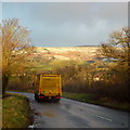
A4077; early morning
The lorry is heading towards Crickhowell. The rising sun is illuminating the southern flank of Pen Cerrig-calch on the other side of the Usk valley.
Image: © Jonathan Billinger
Taken: 29 Jan 2015
0.12 miles
3
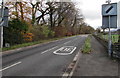
A4077 from Legar towards Gilwern
The 30mph speed limit through Legar, a hamlet near Crickhowell, increases to the National Speed Limit.
The trees and bushes on the left are on a bank of the River Usk.
Image: © Jaggery
Taken: 22 Nov 2015
0.16 miles
4
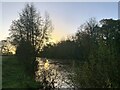
Gwawr ar Afon Wysg
The sun is rising on a rain-swollen River Usk just outside Crickhowell.
Image: © Mike Parker
Taken: 25 Nov 2022
0.20 miles
5
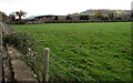
Field beyond the houses in Legar
On the south side of the A4077 beyond the eastern end of houses in Legar (or The Legar), a hamlet near Crickhowell.
Image: © Jaggery
Taken: 22 Nov 2015
0.21 miles
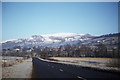
6
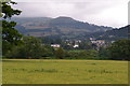
Field near Llangattock with Table Mountain beyond
Image: © David Martin
Taken: 19 Jul 2017
0.24 miles