IMAGES TAKEN NEAR TO
Llangenny, CRICKHOWELL, NP8 1EU
Introduction
This page details the photographs taken nearby to NP8 1EU by members of the Geograph project.
The Geograph project started in 2005 with the aim of publishing, organising and preserving representative images for every square kilometre of Great Britain, Ireland and the Isle of Man.

There are currently over 7.5m images from over14,400 individuals and you can help contribute to the project by visiting https://www.geograph.org.uk
Image Map
Images are licensed for reuse under creativecommons.org/licenses/by-sa/2.0
Notes
- Clicking on the map will re-center to the selected point.
- The higher the marker number, the further away the image location is from the centre of the postcode.
Image Listing (15 Images Found)
Images are licensed for reuse under creativecommons.org/licenses/by-sa/2.0
Image
Details
Distance
1
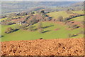
Dan-y-cefn
View to Dan-y-cefn and surrounding fields from the open hillside of Sugar Loaf.
Image: © Philip Halling
Taken: 13 Dec 2014
0.01 miles
2
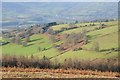
Farmland above the Usk valley
Farmland above the Usk valley viewed from the slopes of Sugar Loaf.
Image: © Philip Halling
Taken: 13 Dec 2014
0.09 miles
4
Footpath in the Black Mountains
The Usk valley should be visible ahead but the weather is 'changeable'.
Image: © Jeremy Bolwell
Taken: 11 Aug 2011
0.11 miles
5
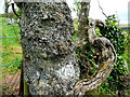
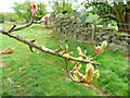
Gnarled or what?
The old man of the tree beckons with his one good arm!
Image: © Jonathan Billinger
Taken: 3 May 2009
0.12 miles
6

Above Dan-y-cefn
Pastures on the steep slopes above the farm, leading down towards the Usk valley.
Image: © Graham Horn
Taken: 3 May 2009
0.12 miles
7
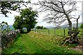
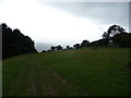
Bridleway to Pen-twyn
There are many bridleways giving access to the western slopes of Sugar Loaf. This is one of them through sheep pasture on the lower slopes.
Image: © Graham Horn
Taken: 3 May 2009
0.12 miles
8
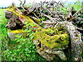
Mossy logs 2
This pile of organic matter is by the path to Pen-twyn.
See also Image
Image: © Jonathan Billinger
Taken: 3 May 2009
0.12 miles
9
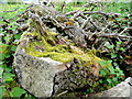
Mossy logs 3
Quietly rotting away on the lower slopes of Sugarloaf...
Image: © Jonathan Billinger
Taken: 3 May 2009
0.12 miles
10
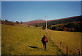
Uwchben / Above Cwm Cegyr
Cerddwr yn dilyn llwybr cyhoeddus uchben Ffarm Cwm Cegyr. Yn y pellter mae copa Pen y Fal.
Walker following a public footpath above Cwm Cegyr Farm. The peak in the distance is the Sugar Loaf.
Image: © Alan Richards
Taken: 28 Oct 1997
0.13 miles