IMAGES TAKEN NEAR TO
Glangrwyney, CRICKHOWELL, NP8 1ET
Introduction
This page details the photographs taken nearby to NP8 1ET by members of the Geograph project.
The Geograph project started in 2005 with the aim of publishing, organising and preserving representative images for every square kilometre of Great Britain, Ireland and the Isle of Man.

There are currently over 7.5m images from over14,400 individuals and you can help contribute to the project by visiting https://www.geograph.org.uk
Image Map
Images are licensed for reuse under creativecommons.org/licenses/by-sa/2.0
Notes
- Clicking on the map will re-center to the selected point.
- The higher the marker number, the further away the image location is from the centre of the postcode.
Image Listing (7 Images Found)
Images are licensed for reuse under creativecommons.org/licenses/by-sa/2.0
Image
Details
Distance
1
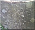
Ordnance Survey Cut Mark
This OS cut mark can be found on a stile east side of the road. It marks a point 90.584m above mean sea level.
Image: © Adrian Dust
Taken: 6 Jul 2020
0.10 miles
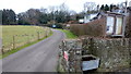
2
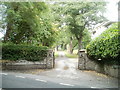
Entrance drive to Glangrwyney Court, Powys
Viewed across the A40. The entrance drive leads to Glangrwyney Court, about 250 metres away. Built in the early nineteenth century, and originally named Sunny Bank, the country house now offers B&B (bed and breakfast) accommodation. It was Grade II listed in July 1963. The lodge http://www.geograph.org.uk/photo/2480875 is on the right.
Image: © Jaggery
Taken: 19 Jun 2011
0.22 miles
3
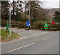
Christmas tree depictions on a Glangrwyney corner, Powys
Viewed across the A40 on January 1st 2019. The red arrow on the tree depiction on the right points along the minor road to Llangenny. The blue sign shows that the minor road is unsuitable for HGVs (heavy goods vehicles).
Image: © Jaggery
Taken: 1 Jan 2019
0.22 miles
4
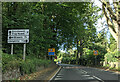
Entering Glangrwyney on the A40, heading west
Image: © Rob Purvis
Taken: 24 Sep 2021
0.23 miles
5
Public footpath on the north side of the A40, Glangrwyney, Powys
Pointing ahead, a public footpath sign is near the camera.
Image: © Jaggery
Taken: 1 Jan 2019
0.23 miles
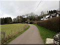
6
Footpath north from Glangrwyney
A water trough here would seem to be a rare throwback to the horse-drawn age.
Image: © Jonathan Billinger
Taken: 5 Feb 2015
0.24 miles
7
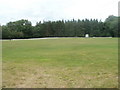
Playing field. Glangrwyney, Powys
The field occupies a roughly rectangular site, about 150 metres by 130 metres, on the north side of the A40 in the hamlet of Glangrwyney.
Image: © Jaggery
Taken: 19 Jun 2011
0.24 miles