IMAGES TAKEN NEAR TO
Glangrwyney, CRICKHOWELL, NP8 1EF
Introduction
This page details the photographs taken nearby to NP8 1EF by members of the Geograph project.
The Geograph project started in 2005 with the aim of publishing, organising and preserving representative images for every square kilometre of Great Britain, Ireland and the Isle of Man.

There are currently over 7.5m images from over14,400 individuals and you can help contribute to the project by visiting https://www.geograph.org.uk
Image Map
Images are licensed for reuse under creativecommons.org/licenses/by-sa/2.0
Notes
- Clicking on the map will re-center to the selected point.
- The higher the marker number, the further away the image location is from the centre of the postcode.
Image Listing (91 Images Found)
Images are licensed for reuse under creativecommons.org/licenses/by-sa/2.0
Image
Details
Distance
1
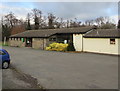
Glangrwyney Village Hall
Set back from the north side of the A40 in Glangrwyney, Powys.
Image: © Jaggery
Taken: 1 Jan 2019
0.01 miles
4
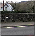
A40 marker on a Glangrwyney wall, Powys
Showing A40 360 W98 above a marker showing 7188, the marker is
on the stone wall on the south side of the A40 opposite the village hall. https://www.geograph.org.uk/photo/6342210
Image: © Jaggery
Taken: 1 Jan 2019
0.03 miles
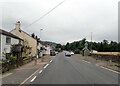
5
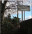
Directions sign alongside the A40, Glangrwyney, Powys
Viewed from this track https://www.geograph.org.uk/photo/6342583 a mile from Llangenny, a mile and a half from Gilwern.
The location 2¾ miles away has been obliterated.
Image: © Jaggery
Taken: 1 Jan 2019
0.03 miles
6
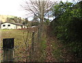
Track from river to road, Glangrwyney, Powys
Ascending from a bank of the river Grwyne Fawr towards the A40, the main road through Glangrwyney. Glangrwyney Village Hall https://www.geograph.org.uk/photo/6342210 is in the background.
Image: © Jaggery
Taken: 1 Jan 2019
0.03 miles
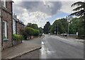
7
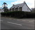
House behind a hedge, Glangrwyney, Powys
On the south side of the A40, the main road through Glangrwyney.
Image: © Jaggery
Taken: 1 Jan 2019
0.03 miles
8
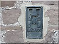
Ordnance Survey Flush Bracket G2972
This can be found on the roadside wall of a house in Glangrwyney.
For more detail see : http://www.bench-marks.org.uk/bm2538
Image: © Peter Wood
Taken: 21 Oct 2016
0.03 miles
9
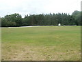
Playing field. Glangrwyney, Powys
The field occupies a roughly rectangular site, about 150 metres by 130 metres, on the north side of the A40 in the hamlet of Glangrwyney.
Image: © Jaggery
Taken: 19 Jun 2011
0.03 miles
10
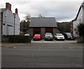
Cars on the south side of the A40, Glangrwyney, Powys
I wondered if the modern building behind the cars could be
a rebuild of an old fire station, but that idea is probably fanciful.
Image: © Jaggery
Taken: 1 Jan 2019
0.04 miles