IMAGES TAKEN NEAR TO
CRICKHOWELL, NP8 1AW
Introduction
This page details the photographs taken nearby to NP8 1AW by members of the Geograph project.
The Geograph project started in 2005 with the aim of publishing, organising and preserving representative images for every square kilometre of Great Britain, Ireland and the Isle of Man.

There are currently over 7.5m images from over14,400 individuals and you can help contribute to the project by visiting https://www.geograph.org.uk
Image Map (Loading...)


Getting Data...Please wait
Leaflet Map data © OpenStreetMap
Images are licensed for reuse under creativecommons.org/licenses/by-sa/2.0
Notes
- Clicking on the map will re-center to the selected point.
- The higher the marker number, the further away the image location is from the centre of the postcode.
Image Listing (314 Images Found)
Images are licensed for reuse under creativecommons.org/licenses/by-sa/2.0
Image
Details
Distance
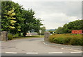
1
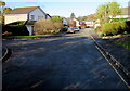
Roadway at the SE end of Everest Drive, Crickhowell
Looking NW from a path at the end of the road. The A40 Brecon Road is about 230 metres ahead, out of shot.
Image: © Jaggery
Taken: 22 Nov 2015
0.05 miles
2
Crickhowell - view from the bridge on a June evening
Image: © Keith Salvesen
Taken: 19 Jun 2008
0.09 miles
3
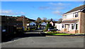
Eastern arm of Everest Drive, Crickhowell
On the east side of the main (roughly north-south) course of Everest Drive.
A nearby sign shows 25-43 Everest Drive.
Image: © Jaggery
Taken: 22 Nov 2015
0.09 miles
4
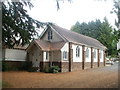
St Joseph's Catholic church, Crickhowell
Set back about 40 metres from the A40 (Brecon Road). The church is in the parish of Brecon, where most of the Masses are held (at St Michael's Church, Glamorgan Street). There is only one religious service here each week, Mass beginning at 10am on Fridays.
Image: © Jaggery
Taken: 19 Jun 2011
0.10 miles
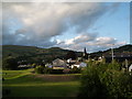
5
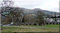
Crickhowell from the south
View from the Llangattock road showing the Usk Bridge, the town, and Table Mountain prominent in the distance.
Image: © Jonathan Billinger
Taken: 14 Mar 2008
0.10 miles
6
New Road entrance to Crickhowell High School
Image: © Jaggery
Taken: 30 Jun 2010
0.11 miles
7
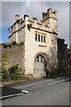
Porth Mawr gatehouse
Porth Mawr is a late 15th century gatehouse on Brecon Road in Crickhowell. It was the gatehouse of the Herbert house of Cwrt-y-carw which is no longer standing.
Image: © Philip Halling
Taken: 5 May 2021
0.11 miles
8
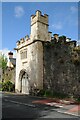
Porth Mawr gatehouse
Porth Mawr is a late 15th century gatehouse on Brecon Road in Crickhowell. It was the gatehouse of the Herbert house of Cwrt-y-carw which is no longer standing.
Image: © Philip Halling
Taken: 5 May 2021
0.11 miles
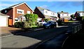
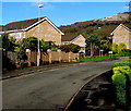
9
Western arm of Everest Drive, Crickhowell
On the west side of the main (roughly north-south) course of Everest Drive.
The sign in shadow on the left shows 12-28 Everest Drive.
Image: © Jaggery
Taken: 22 Nov 2015
0.12 miles
10
Everest Drive towards Brookfields, Crickhowell
North along Everest Drive towards the left turn for Brookfields http://www.geograph.org.uk/photo/4746898
in an area of modern housing on the south side of the A40 Brecon Road.
Image: © Jaggery
Taken: 22 Nov 2015
0.13 miles