IMAGES TAKEN NEAR TO
Cwrt Newydd, Greenhill Way, CRICKHOWELL, NP8 1AQ
Introduction
This page details the photographs taken nearby to Cwrt Newydd, Greenhill Way, NP8 1AQ by members of the Geograph project.
The Geograph project started in 2005 with the aim of publishing, organising and preserving representative images for every square kilometre of Great Britain, Ireland and the Isle of Man.

There are currently over 7.5m images from over14,400 individuals and you can help contribute to the project by visiting https://www.geograph.org.uk
Image Map
Images are licensed for reuse under creativecommons.org/licenses/by-sa/2.0
Notes
- Clicking on the map will re-center to the selected point.
- The higher the marker number, the further away the image location is from the centre of the postcode.
Image Listing (433 Images Found)
Images are licensed for reuse under creativecommons.org/licenses/by-sa/2.0
Image
Details
Distance
1
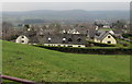
View from a Standard Street field gate, Crickhowell
Towards Cwrt Newydd houses.
Image: © Jaggery
Taken: 17 Feb 2019
0.02 miles
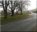
2
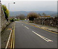
Down Greenhill Way, Crickhowell
Greenhill Way descends from Standard Street towards the A40 Beaufort Street.
Image: © Jaggery
Taken: 17 Feb 2019
0.04 miles
3
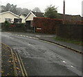
Junction of Greenhill Way and Cwrt Newydd, Crickhowell
From the right, Cwrt Newydd joins Greenhill Way.
Ahead along Greenhill Way for Standard Street.
Image: © Jaggery
Taken: 29 Nov 2020
0.05 miles
4
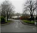
Greenhill Way, Crickhowell
Viewed across the A40 Beaufort Street. Greenhill Way leads to Standard Street.
Image: © Jaggery
Taken: 29 Nov 2020
0.05 miles
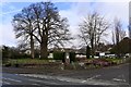
5
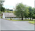
Deciduous trees, Greenhill Way, Crickhowell
Viewed in late November 2020.
Image: © Jaggery
Taken: 29 Nov 2020
0.05 miles
6
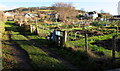
Crickhowell allotments
The SE side of allotments located between the town centre car park and Greenhill Way.
The allotments are managed by an allotment association on behalf of Powys County Council.
In December 2014, the council website states that there are currently 32 full plots and 10 half plots here, all of which are occupied.
Image: © Jaggery
Taken: 19 Dec 2014
0.06 miles
7
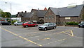
Crickhowell public car park
Located behind the Resource & Information Centre (the building on the right). The car park entrance is in Greenhill Way, the turning from the A40 (Beaufort Street) at the corner of the Fire Station. http://www.geograph.org.uk/photo/460697
Image: © Jaggery
Taken: 17 Jun 2012
0.07 miles
8
War Memorial Health Centre, Crickhowell
Set back from Beaufort Street (A40), a few tens of metres from the War Memorial. http://www.geograph.org.uk/photo/2469372
The site was formerly occupied by Crickhowell War Memorial Hospital.
Image: © Jaggery
Taken: 19 Jun 2011
0.07 miles
9
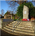
Crickhowell War Memorial
Steps lead up to the War Memorial at the edge of the A40 Beaufort Street. The 3 metre (10 feet) high granite stone is near the site of the demolished Crickhowell War Memorial Hospital.
Image: © Jaggery
Taken: 19 Dec 2014
0.07 miles
10
Crickhowell War Memorial
On Beaufort Street.
Image: © Andrew Abbott
Taken: 14 Mar 2020
0.07 miles