IMAGES TAKEN NEAR TO
Beaufort Street, CRICKHOWELL, NP8 1AJ
Introduction
This page details the photographs taken nearby to Beaufort Street, NP8 1AJ by members of the Geograph project.
The Geograph project started in 2005 with the aim of publishing, organising and preserving representative images for every square kilometre of Great Britain, Ireland and the Isle of Man.

There are currently over 7.5m images from over14,400 individuals and you can help contribute to the project by visiting https://www.geograph.org.uk
Image Map
Images are licensed for reuse under creativecommons.org/licenses/by-sa/2.0
Notes
- Clicking on the map will re-center to the selected point.
- The higher the marker number, the further away the image location is from the centre of the postcode.
Image Listing (349 Images Found)
Images are licensed for reuse under creativecommons.org/licenses/by-sa/2.0
Image
Details
Distance
1
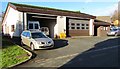
Crickhowell ambulance station
Set back from the north side of Llangenny Lane, near the A40 junction in the SE of Crickhowell.
The nameboard shows Welsh Ambulance Services CRICKHOWELL AMBULANCE STATION.
Image: © Jaggery
Taken: 19 Dec 2014
0.05 miles
2
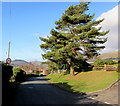
Conifer alongside the start of the 30 zone in Crickhowell
The National Speed Limit reduces to 30mph along Standard Street.
Image: © Jaggery
Taken: 19 Dec 2014
0.06 miles
3
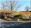
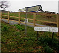
Bench, signpost and grit box opposite the eastern end of Standard Street, Crickhowell
On the corner of Great Oak Road and Bellfountain Road.
The signpost arm pointing left along Great Oak Road shows 4 (miles) to Grwynefechan.
The arm pointing right along Bellfountain Road shows Llanbedr 2 and Llangenny 2¼.
Image: © Jaggery
Taken: 19 Dec 2014
0.06 miles
4
Wooden bench on a Crickhowell corner
On the corner of Great Oak Road and Bellfountain Road.
Image: © Jaggery
Taken: 17 Feb 2019
0.06 miles
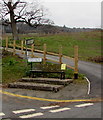
5
Great Oak Road direction and distances signs, Crickhowell
Left for Grwynefechan (4 miles). Right for Llanbedr (2) and Llangenny (2¼)
Image: © Jaggery
Taken: 17 Feb 2019
0.06 miles
6
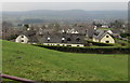
View from a Standard Street field gate, Crickhowell
Towards Cwrt Newydd houses.
Image: © Jaggery
Taken: 17 Feb 2019
0.07 miles
7
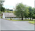
War Memorial Health Centre, Crickhowell
Set back from Beaufort Street (A40), a few tens of metres from the War Memorial. http://www.geograph.org.uk/photo/2469372
The site was formerly occupied by Crickhowell War Memorial Hospital.
Image: © Jaggery
Taken: 19 Jun 2011
0.07 miles
8

Bellfountain Road, Crickhowell
Bellfountain Road ascends eastwards away from Standard Street and Great Oak Road behind the camera.
Image: © Jaggery
Taken: 17 Feb 2019
0.07 miles
9
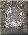
Old Milestone by the A40, Beaufort Street, Crickhowell
Stone post in wall by the A40, in parish of Crickhowell (Powys District), Beaufort Street, Crickhowell. In front of Health Centre, inset into wall, Southeast of war memorial.
Inscription reads:-
BRECON
14
Surveyed
Milestone Society National ID: BRE_BCAG14
Image: © Milestone Society
Taken: Unknown
0.08 miles
10
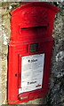
King George VI postbox in Crickhowell
In a Llangenny Lane wall near the A40 junction. In December 2014,
last collection time is shown as 7am on Saturdays and 9am on Mondays-Fridays,
when a 4pm or later collection is made from the postbox at Crickhowell
post office http://www.geograph.org.uk/photo/4283249 and at 6pm from St Johns Square, Abergavenny.
Image: © Jaggery
Taken: 19 Dec 2014
0.08 miles