IMAGES TAKEN NEAR TO
Coldbrook, ABERGAVENNY, NP7 9ST
Introduction
This page details the photographs taken nearby to NP7 9ST by members of the Geograph project.
The Geograph project started in 2005 with the aim of publishing, organising and preserving representative images for every square kilometre of Great Britain, Ireland and the Isle of Man.

There are currently over 7.5m images from over14,400 individuals and you can help contribute to the project by visiting https://www.geograph.org.uk
Image Map
Images are licensed for reuse under creativecommons.org/licenses/by-sa/2.0
Notes
- Clicking on the map will re-center to the selected point.
- The higher the marker number, the further away the image location is from the centre of the postcode.
Image Listing (4 Images Found)
Images are licensed for reuse under creativecommons.org/licenses/by-sa/2.0
Image
Details
Distance
1
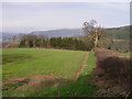
Towards Coldbrook Park
The local countryside is a patchwork of fields and both coniferous plantations and copses spread across rolling hills. The afforested western slopes of Ysgyryd Fach can be seen as can the distinctive shape of Y Fal / Sugarloaf - visible in so many views in the Abergavenny area.
Image: © Alan Bowring
Taken: 11 Mar 2007
0.16 miles
2
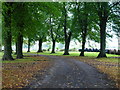
Bend in the road, Coldbrook, Abergavenny
Image: © Ruth Sharville
Taken: 25 Oct 2013
0.17 miles
3
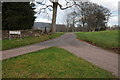
Drive to Coldbrook Park
Private road to Coldbrook Park.
Image: © Philip Halling
Taken: 14 Jan 2012
0.22 miles
4
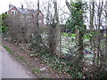
Garden near Coldbrook Park
Snowdrops plaster this cottage garden in February.
Image: © Jeremy Bolwell
Taken: 17 Feb 2012
0.25 miles