IMAGES TAKEN NEAR TO
Tyla, ABERGAVENNY, NP7 9RU
Introduction
This page details the photographs taken nearby to Tyla, NP7 9RU by members of the Geograph project.
The Geograph project started in 2005 with the aim of publishing, organising and preserving representative images for every square kilometre of Great Britain, Ireland and the Isle of Man.

There are currently over 7.5m images from over14,400 individuals and you can help contribute to the project by visiting https://www.geograph.org.uk
Image Map
Images are licensed for reuse under creativecommons.org/licenses/by-sa/2.0
Notes
- Clicking on the map will re-center to the selected point.
- The higher the marker number, the further away the image location is from the centre of the postcode.
Image Listing (5 Images Found)
Images are licensed for reuse under creativecommons.org/licenses/by-sa/2.0
Image
Details
Distance
1
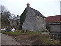
Part of Tyla Farm
An interesting range of old stone barns and outbuildings.
Image: © Jeremy Bolwell
Taken: 2 Mar 2013
0.01 miles
2
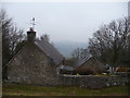
Upland properties above Govilon
With a great distant view cross the Usk Valley to the Sugar Loaf / Mynydd Pen y fal.
Image: © Jeremy Bolwell
Taken: 2 Mar 2013
0.08 miles
3
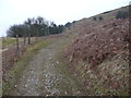
Hillside track
A steep but business-like track, gaining height and promising rewards of views and sights as yet unseen.
Image: © Jeremy Bolwell
Taken: 2 Mar 2013
0.17 miles
4
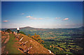
Tramway on Gilwern Hill
Looking north across the Usk valley to the distinctive cone of the Sugar Loaf (Y Fal). On the extreme right is The Skirrid (Ysgyryd Fawr). This is part of Thomas Hill's Tramroad, which served the quarries on Gilwern Hill and Blorenge.
http://www.world-heritage-blaenavon.org.uk/whs-info/nomination/hills/hilltram.htm
Image: © Trevor Rickard
Taken: Unknown
0.21 miles
5
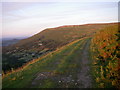
Former tramway on Gilwern Hill
The route contours above the steepest slopes at about 1200ft. The northwestern flank of Blorenge beyond is illuminated by the evening light. Ysgyryd/Skirrid Fach appears truly small in the background to the left.
Image: © Alan Bowring
Taken: 18 Jul 2007
0.23 miles