IMAGES TAKEN NEAR TO
Stephens Crescent, ABERGAVENNY, NP7 9RL
Introduction
This page details the photographs taken nearby to Stephens Crescent, NP7 9RL by members of the Geograph project.
The Geograph project started in 2005 with the aim of publishing, organising and preserving representative images for every square kilometre of Great Britain, Ireland and the Isle of Man.

There are currently over 7.5m images from over14,400 individuals and you can help contribute to the project by visiting https://www.geograph.org.uk
Image Map
Images are licensed for reuse under creativecommons.org/licenses/by-sa/2.0
Notes
- Clicking on the map will re-center to the selected point.
- The higher the marker number, the further away the image location is from the centre of the postcode.
Image Listing (180 Images Found)
Images are licensed for reuse under creativecommons.org/licenses/by-sa/2.0
Image
Details
Distance
1
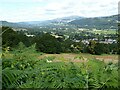
The Usk valley
The Usk valley viewed from the B4246 above Govilon. The Black Mountains can be seen in the distance.
Image: © Philip Halling
Taken: 29 Jul 2021
0.02 miles
2
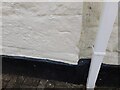
Ordnance Survey Cut Mark
This OS cut mark can be found on No2 Greenfields. It marks a point 124.566m above mean sea level.
Image: © Adrian Dust
Taken: 9 Jun 2023
0.05 miles
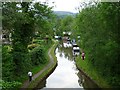
3
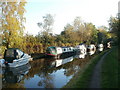
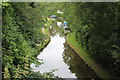
Canal boats, Govilon
The view east along the Monmouthshire and Brecon canal. In the distance is canal bridge 97A. http://www.geograph.org.uk/photo/2159149
Image: © Jaggery
Taken: 22 Oct 2010
0.06 miles
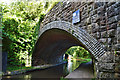
4
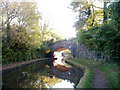
Canal bridge 97A, Govilon
The bridge formerly carried the Abergavenny to Merthyr Tydfil railway lines. Govilon station was about 400 metres to the southwest. Passenger services ceased in 1958.
Image: © Jaggery
Taken: 22 Oct 2010
0.06 miles
5
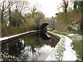
Mon & Brec Canal west of Bridge 97A
Viewed from the former railway viaduct Image
Image: © M J Roscoe
Taken: 13 Jul 2019
0.06 miles
6
Monmouthshire & Brecon Canal, near Govilon
The bridge once carried the Merthyr, Tredegar & Abergavenny Railway, which is now a cycle path.
Image: © Gareth James
Taken: 27 Nov 2010
0.06 miles
7
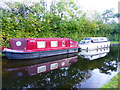
Boats moored at Govilon
The names often amuse me. One here is named 'Red Dwarf' for obvious reasons.
Image: © Jeremy Bolwell
Taken: 10 Nov 2013
0.06 miles
8
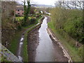
A depleted Monmouthshire & Brecon Canal
Whilst British Waterways completes repairs and further survey work on the central section of this waterway, the canal through Govilon remains un-navigable other than by ducks.
Image: © Alan Bowring
Taken: 11 Apr 2008
0.06 miles
9
Former Heads of the Valleys railway bridge, Govilon
The Merthyr, Tredegar and Abergavenny Railway obtained Royal assent on 1st August 1859. After financial difficulties could not be overcome, the London and North Western Railway initially took a 1,000 year lease and then purchased the line outright. The Heads of the Valleys line was heavily engineered and passed through hostile upland terrain on its way to Merthyr. The line was built to a high standard as this skew bridge that took the line over the canal at Govilon demonstrates. The railway closed to passengers on 4th January 1958, long before Dr Beeching, and one of the most spectacular railway journeys in Britain was denied to future generations. Much of the trackbed was taken over by the A465, The Heads of the Valleys road.
Image: © Philip Pankhurst
Taken: 12 Aug 2017
0.06 miles
10
Monmouthshire and Brecon Canal at Govilon
The view westward from a former railway bridge which crosses the canal at this point.
Image: © Robin Drayton
Taken: 4 Jun 2011
0.06 miles