1
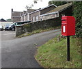
Queen Elizabeth II postbox, School Lane, Govilon
Govilon Learning & Activity Centre http://www.geograph.org.uk/photo/5474941 in the background is in a former school building.
Image: © Jaggery
Taken: 23 Jul 2017
0.02 miles
2
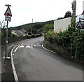
Access road to three houses, Govilon
Ascending from the south side of School Lane near the Cwm Road junction.
Govilon Learning & Activity Centre http://www.geograph.org.uk/photo/5474941 is on the left.
Image: © Jaggery
Taken: 23 Jul 2017
0.02 miles
3
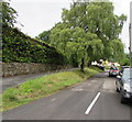
Govilon Learning & Activity Centre, School Lane, Govilon
Located in the former Govilon Infants School which closed in 1969. Built as a National School in 1861.
Image: © Jaggery
Taken: 23 Jul 2017
0.03 miles
4
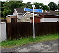
An old school building in Govilon
Now an outward bound type activity centre I think.
Image: © Jeremy Bolwell
Taken: 30 Oct 2016
0.03 miles
5
Humps and humps warning sign, School Lane, Govilon
This way for Stephens Crescent and the B4246.
Image: © Jaggery
Taken: 23 Jul 2017
0.04 miles
6
Crossing Cottage, Govilon
Former level crossing gatekeeper's cottage located opposite the former Govilon railway station. The former railway through Govilon is part of National Cycle Network Route 46, here on the left side of the cottage. Govilon station was closed when passenger services on the Abergavenny to Merthyr line ended in early January 1958.
Image: © Jaggery
Taken: 23 Jul 2017
0.04 miles
7
Junction of School Lane and Cwm Road, Govilon
Cwm Road on the left ascends away from School Lane.
Image: © Jaggery
Taken: 23 Jul 2017
0.04 miles
8
The Old Railway Station name sign, Govilon
On the wall here. http://www.geograph.org.uk/photo/5475002
Image: © Jaggery
Taken: 23 Jul 2017
0.05 miles
9
National Cycle Network Route 46 signpost, Govilon
Here opposite the former Govilon railway station, the combined cycle route and footpath uses the trackbed of the former Abergavenny to Merthyr railway. Passenger trains on this route ceased in early January 1958.
Image: © Jaggery
Taken: 23 Jul 2017
0.05 miles
10
East along National Cycle Network Route 46, Govilon
Here near the former Govilon railway station, the combined cycle route and footpath uses the trackbed of the former Abergavenny to Merthyr railway. Passengers trains on this route ceased in early January 1958.
Image: © Jaggery
Taken: 23 Jul 2017
0.05 miles


