IMAGES TAKEN NEAR TO
Plas Derwen Way, ABERGAVENNY, NP7 9QZ
Introduction
This page details the photographs taken nearby to Plas Derwen Way, NP7 9QZ by members of the Geograph project.
The Geograph project started in 2005 with the aim of publishing, organising and preserving representative images for every square kilometre of Great Britain, Ireland and the Isle of Man.

There are currently over 7.5m images from over14,400 individuals and you can help contribute to the project by visiting https://www.geograph.org.uk
Image Map (Loading...)


Getting Data...Please wait
Leaflet Map data © OpenStreetMap
Images are licensed for reuse under creativecommons.org/licenses/by-sa/2.0
Notes
- Clicking on the map will re-center to the selected point.
- The higher the marker number, the further away the image location is from the centre of the postcode.
Image Listing (136 Images Found)
Images are licensed for reuse under creativecommons.org/licenses/by-sa/2.0
Image
Details
Distance
1
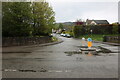
Plas Derwen Way at the junction of Monmouth Road
Abergavenny has recently become virtually all 20mph. Using the main roads is almost impossible in 3rd gear and causes unnecessary strings of traffic on otherwise clear roads.
Image: © David Howard
Taken: 23 Apr 2023
0.04 miles
2
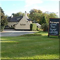
Plas Derwen Hotel, Abergavenny
Hotel with 11 en-suite rooms, bar and restaurant, located on the eastern side of Monmouth Road (A40), at the southern edge of Abergavenny.
Image: © Jaggery
Taken: 20 Oct 2010
0.06 miles
4
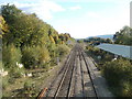
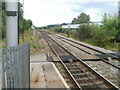
Railway lines heading south from Abergavenny station
The view south from the station footbridge. http://www.geograph.org.uk/photo/2125279
http://www.geograph.org.uk/photo/384675 to a view of the station.
Image: © Jaggery
Taken: 20 Oct 2010
0.08 miles
5
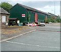
Jones Scaffolding, Station Enterprises, Abergavenny
Jones Scaffolding occupies a 35-metre long corrugated metal building at the southern end of Station Enterprises near Abergavenny railway station.
Image: © Jaggery
Taken: 19 Jun 2011
0.08 miles
6
A view south from Abergavenny railway station
Visible in the distance on the left is the white signal box which controls nearby points and semaphore signals, such as this one. http://www.geograph.org.uk/photo/2738981
Image: © Jaggery
Taken: 19 Jun 2011
0.08 miles
7
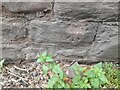
Ordnance Survey Cut Mark
This OS cut mark can be found on Cae Kenfy Lodge, Monmouth Road. It marks a point 60.695m above mean sea level.
Image: © Adrian Dust
Taken: 21 Aug 2023
0.09 miles
8
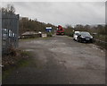
Abergavenny Sidings
Network Rail site viewed through the locked gate at the southern edge of Abergavenny railway station pay & display car park on the site of the former station yard. The board shows Network Rail - Abergavenny Sidings.
Image: © Jaggery
Taken: 31 Dec 2017
0.09 miles
9
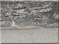
Ordnance Survey Cut Mark
This OS cut mark can be found on the wall NE side of Monmouth Road. It marks a point 61.036m above mean sea level.
Image: © Adrian Dust
Taken: 21 Aug 2023
0.09 miles
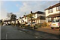
10
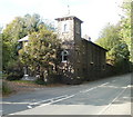
Stone house with tower, Monmouth Road, Abergavenny
Located on the west side of Monmouth Road, south of Station Road.
Image: © Jaggery
Taken: 20 Oct 2010
0.09 miles