IMAGES TAKEN NEAR TO
Blaenavon Road, ABERGAVENNY, NP7 9PF
Introduction
This page details the photographs taken nearby to Blaenavon Road, NP7 9PF by members of the Geograph project.
The Geograph project started in 2005 with the aim of publishing, organising and preserving representative images for every square kilometre of Great Britain, Ireland and the Isle of Man.

There are currently over 7.5m images from over14,400 individuals and you can help contribute to the project by visiting https://www.geograph.org.uk
Image Map
Images are licensed for reuse under creativecommons.org/licenses/by-sa/2.0
Notes
- Clicking on the map will re-center to the selected point.
- The higher the marker number, the further away the image location is from the centre of the postcode.
Image Listing (49 Images Found)
Images are licensed for reuse under creativecommons.org/licenses/by-sa/2.0
Image
Details
Distance
1
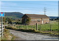
Cadfor Pumping Station
Welsh Water pumping station located between Merthyr Road (B4246) and The Heads of the Valleys Road (A465).
Image: © Jaggery
Taken: 22 Oct 2010
0.02 miles
2
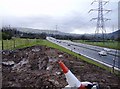
Dualling nearly complete
Looking north-west from the site of the old bridge to Cadfor Farm. The dualling of the A465 is nearly complete, but the carriageway restrictions still remain.
Image: © Graham Horn
Taken: 21 Mar 2008
0.06 miles
3
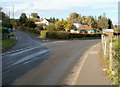
Road to Blaenavon and Big Pit
Roughly midway between Govilon and Llanfoist, a road to Blaenavon (for light vehicles only) heads away from Merthyr Road (B4246). Near the left edge of the view, a white-on-blue sign states
7.5 tonnes max. gross weight 700 yards ahead.
Image: © Jaggery
Taken: 22 Oct 2010
0.06 miles
4
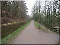
Part of the towpath of the Mon. & Brec. near Govilon
A mum and her daughter have walked past and then start jogging - good for them, great to see. Long may they enjoy a run together. This is London Marathon day. I wonder will they do this race together one day in the future? Hope so. Anything is possible...
Image: © Jeremy Bolwell
Taken: 21 Apr 2013
0.07 miles
5
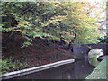
The Monmouthshire & Brecon Canal beside Coed-y-person
Image: © John Lord
Taken: 30 Oct 2012
0.07 miles
6
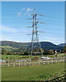
Pylon, Heads of the Valleys Road east of Govilon
The view north from Merthyr Road (B4246) across a field towards a pylon alongside the Heads of the Valleys Road (A465).
Image: © Jaggery
Taken: 22 Oct 2010
0.08 miles
7
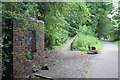
Cycle route junction
The inclined path, left, a spur of NCR 49, joins NCR 46 on the dismantled railway.
Image: © M J Roscoe
Taken: 13 Jul 2019
0.08 miles
8
Farm access road heads west towards Cadfor
Viewed from the edge of a bridge http://www.geograph.org.uk/photo/2160492 across the Heads of the Valleys Road (A465). A fenced access road runs parallel with the A465, heading for Cadfor farms.
Image: © Jaggery
Taken: 22 Oct 2010
0.08 miles
9
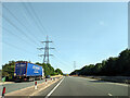
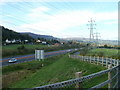
Layby and power lines on the A465 heading east
Image: © Rob Purvis
Taken: 14 Sep 2022
0.08 miles
10
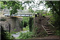
Cycle route bridge over Blaenavon Road
The original railway bridge having been removed, later a steel bridge for NCR 46 was installed.
Image: © M J Roscoe
Taken: 13 Jul 2019
0.09 miles