IMAGES TAKEN NEAR TO
Llanfoist, ABERGAVENNY, NP7 9PE
Introduction
This page details the photographs taken nearby to NP7 9PE by members of the Geograph project.
The Geograph project started in 2005 with the aim of publishing, organising and preserving representative images for every square kilometre of Great Britain, Ireland and the Isle of Man.

There are currently over 7.5m images from over14,400 individuals and you can help contribute to the project by visiting https://www.geograph.org.uk
Image Map
Images are licensed for reuse under creativecommons.org/licenses/by-sa/2.0
Notes
- Clicking on the map will re-center to the selected point.
- The higher the marker number, the further away the image location is from the centre of the postcode.
Image Listing (42 Images Found)
Images are licensed for reuse under creativecommons.org/licenses/by-sa/2.0
Image
Details
Distance
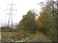
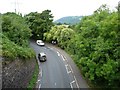
2
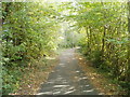
Cycle route along former railway route
The cycleway (and footpath) uses the railbed of the dismantled Abergavenny to Brynmawr line. This section is heading for Llanfoist.
Image: © Jaggery
Taken: 22 Oct 2010
0.05 miles
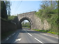
3
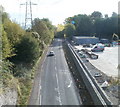
B4246 heads for Llanfoist, away from an arch bridge
Viewed from the edge of a cycleway across an arch bridge. http://www.geograph.org.uk/photo/2174478
Image: © Jaggery
Taken: 22 Oct 2010
0.06 miles
4
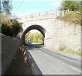
Arch bridge above B4246 viewed from the east side
This 16 feet headroom bridge formerly carried the Abergavenny to Brynmawr railway route above the B4246. The railbed of the dismantled railway is now used for a combined cycleway and footpath.
http://www.geograph.org.uk/photo/2174472 to the view from the other side.
Image: © Jaggery
Taken: 22 Oct 2010
0.06 miles
5
Cycle path near Llanfoist
This was once the Merthyr, Tredegar & Abergavenny Railway.
Image: © Gareth James
Taken: 27 Nov 2010
0.07 miles
6
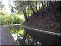
Monmouthshire & Brecon Canal at Coed-y-person
Image: © John Lord
Taken: 30 Oct 2012
0.08 miles
7
Bridge over the B4246
Now carries a multi user track on a former rail line
Image: © Peter Robinson
Taken: 21 Apr 2015
0.08 miles
8
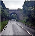
SE side of a stone bridge over the B4246 Brecon Road west of Abergavenny
This 16 feet headroom bridge formerly carried the Abergavenny to Brynmawr
railway above the B4246. The railbed of the dismantled railway is now used
for a combined cycleway and footpath.
Image: © Jaggery
Taken: 17 Sep 2023
0.08 miles
9
B4246 passing under the former railway near Govilon
The former heads of the valleys railway line is now a footpath and cycleway. For a view from below, see Image
Image: © Christine Johnstone
Taken: 11 Sep 2013
0.10 miles
10
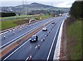
Dualling nearly complete
Looking east from the new farm access bridge over the recently dualled A465. The carriageway is nearly complete, but single lane working with a 30 mph speed limit still applies. The hill on the horizon is Ysgyryd Fach.
Image: © Graham Horn
Taken: 21 Mar 2008
0.11 miles