IMAGES TAKEN NEAR TO
The Cutting, ABERGAVENNY, NP7 9NL
Introduction
This page details the photographs taken nearby to The Cutting, NP7 9NL by members of the Geograph project.
The Geograph project started in 2005 with the aim of publishing, organising and preserving representative images for every square kilometre of Great Britain, Ireland and the Isle of Man.

There are currently over 7.5m images from over14,400 individuals and you can help contribute to the project by visiting https://www.geograph.org.uk
Image Map
Images are licensed for reuse under creativecommons.org/licenses/by-sa/2.0
Notes
- Clicking on the map will re-center to the selected point.
- The higher the marker number, the further away the image location is from the centre of the postcode.
Image Listing (176 Images Found)
Images are licensed for reuse under creativecommons.org/licenses/by-sa/2.0
Image
Details
Distance
1
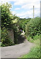
Masonry remains of a railway bridge near The Cutting, Llanfoist
In June 2017, the stone remains of bridge supports are on both sides
of a side road descending from the cul-de-sac named The Cutting.
Old maps show a railway line here. It was part of the line
from Abergavenny to Brynmawr, long since closed and dismantled.
Image: © Jaggery
Taken: 11 Jun 2017
0.02 miles
2
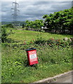
Red bin for dog waste only, The Cutting, Llanfoist
The notice shows that the red bin is for dog waste only. No litter, no bottles, no cat litter, strictly no bulk.
Misuse of this facility will result in it being withdrawn, and possible prosecution.
The Cutting is a residential cul-de-sac extending for 300 metres from Merthyr Road
to an underpass (for walkers and cyclists) beneath the A465 Heads of the Valleys Road.
Image: © Jaggery
Taken: 11 Jun 2017
0.02 miles
3
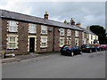
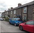
Houses in The Cutting, Llanfoist
Viewed from the corner of the B4246 Merthyr Road.
Image: © Jaggery
Taken: 11 Jun 2017
0.03 miles
4
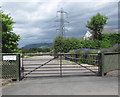
Waterloo Court entrance gate, Llanfoist
The gate is alongside The Cutting, a residential cul-de-sac extending for 300 metres from Merthyr Road to an underpass (for walkers and cyclists) beneath the A465 Heads of the Valleys Road. In the background is one of many electricity pylons in the Llanfoist area.
Image: © Jaggery
Taken: 11 Jun 2017
0.03 miles
5
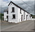
Row of stone houses, The Cutting, Llanfoist
A small part of The Cutting, a residential cul-de-sac extending for 300 metres from Merthyr Road to an underpass (for walkers and cyclists) beneath the A465 Heads of the Valleys Road.
Image: © Jaggery
Taken: 11 Jun 2017
0.03 miles
6
Chapel House and Chapel Cottage, The Cutting, Llanfoist
Two of many dwellings in The Cutting, a residential cul-de-sac extending for 300 metres from Merthyr Road to an underpass (for walkers and cyclists) beneath the A465 Heads of the Valleys Road.
Image: © Jaggery
Taken: 11 Jun 2017
0.04 miles
7
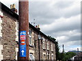
Cycle Across The Beacons sign, The Cutting, Llanfoist
Below (National Cycle Network route) 46, the orange part of the sign shows
CYCLE ACROSS THE (BRECON) BEACONS.
The Cutting is a residential cul-de-sac extending for 300 metres from Merthyr Road
to an underpass (for walkers and cyclists) beneath the A465 Heads of the Valleys Road.
Image: © Jaggery
Taken: 11 Jun 2017
0.05 miles
8
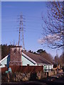
Ugly pylon
Have you got used to having these monster pylons taking cables across your countryside? We'd have less of them if wind farms were allowed for local electricity supplies.
Image: © Graham Cole
Taken: 13 Mar 2011
0.05 miles
9
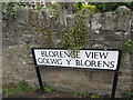
Blorenge View/Golwg y Blorens name sign, Llanfoist
The English/Welsh sign faces Merthyr Road near the corner of The Cutting.
Image: © Jaggery
Taken: 11 Jun 2017
0.05 miles
10
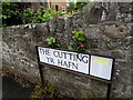
The Cutting/Yr Hafn name sign, Llanfoist
The English/Welsh sign is at the SW end of The Cutting, near the corner of Merthyr Road.
Image: © Jaggery
Taken: 11 Jun 2017
0.05 miles