IMAGES TAKEN NEAR TO
St. Faiths Close, ABERGAVENNY, NP7 9NJ
Introduction
This page details the photographs taken nearby to St. Faiths Close, NP7 9NJ by members of the Geograph project.
The Geograph project started in 2005 with the aim of publishing, organising and preserving representative images for every square kilometre of Great Britain, Ireland and the Isle of Man.

There are currently over 7.5m images from over14,400 individuals and you can help contribute to the project by visiting https://www.geograph.org.uk
Image Map
Images are licensed for reuse under creativecommons.org/licenses/by-sa/2.0
Notes
- Clicking on the map will re-center to the selected point.
- The higher the marker number, the further away the image location is from the centre of the postcode.
Image Listing (104 Images Found)
Images are licensed for reuse under creativecommons.org/licenses/by-sa/2.0
Image
Details
Distance
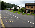
1
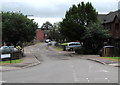
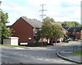
St Faith's Close, Llanfoist
Cul-de-sac on the east side of the B4269 Gypsy Lane.
Image: © Jaggery
Taken: 11 Jun 2017
0.01 miles
2
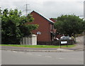
Electricity substation below a Llanfoist corner
The grey cabinet below the corner of St Faith's Close and Gypsy Lane is a
Western Power Distribution electricity substation. Its identifier is GYPSY LANE S/S 53-4001.
Image: © Jaggery
Taken: 11 Jun 2017
0.04 miles
3
Westgate Yard Garage and pylon , Llanfoist
Premises of J.M.Watkins, located on the east side of Merthyr Road, near the A465 (Heads of the Valleys Road) roundabout.
Image: © Jaggery
Taken: 22 Oct 2010
0.04 miles
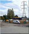
4
Entrance to Llanfoist Recycling Centre
The entrance road, from Merthyr Road, runs parallel with the Heads of the Valleys Road (A465).
Safety instructions on the large sign are:
Children must remain inside vehicles at all times.
Please observe 5mph speed limit and traffic safety signs.
Image: © Jaggery
Taken: 22 Oct 2010
0.04 miles
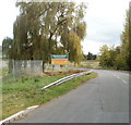
5
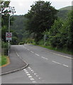
Warning sign - Patrol/Hebryngwr, Gypsy Lane, Llanfoist
The English/Welsh sign faces the B4269 Gypsy Lane on the approach to the village primary school.
Image: © Jaggery
Taken: 11 Jun 2017
0.04 miles
6
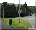
Golf club direction sign, Llanfoist
The symbolic brown and white sign on a lamppost faces the B4246 Merthyr Road.
Turn left ahead on to the B4269 Gypsy Lane for The Monmouthshire Golf Club.
Image: © Jaggery
Taken: 11 Jun 2017
0.05 miles
7
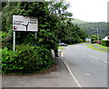
Directions sign alongside Merthyr Road Llanfoist
Alongside the B4246 Merthyr Road on the approach to the B4269 junction for Llanellen.
The small brown and white symbol indicates a golf course.
Image: © Jaggery
Taken: 11 Jun 2017
0.05 miles
8
St Faith's Close, Llanfoist
Modern houses viewed from the corner of Gipsy Lane.
Image: © Jaggery
Taken: 22 Oct 2010
0.05 miles
9
Merthyr Road bus stop opposite Briardene, Llanfoist
This stop on the B4246 Merthyr Road is on Stagecoach bus route X4 from Abergavenny to Cardiff
via Govilon, Gilwern, Brynmawr, Ebbw Vale, Tredegar, Merthyr Tydfil and Pontypridd.
SAFLE BWS is Welsh for BUS STOP. The cul-de-sac Briardene http://www.geograph.org.uk/photo/5427669 is on the right
Image: © Jaggery
Taken: 11 Jun 2017
0.05 miles
10
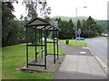
Vandalised Gipsy Lane bus shelter, Llanfoist
In June 2017, there is no glass in any of the shelter frames, presumably because of vandalism.
The shelter is alongside Merthyr Road at this http://www.geograph.org.uk/photo/5427765 bus stop.
The name on the bus stop sign on the shelter is Gipsy Lane.
The Gipsy Lane junction is in the background.
Image: © Jaggery
Taken: 11 Jun 2017
0.05 miles