IMAGES TAKEN NEAR TO
Glyndwr Gardens, ABERGAVENNY, NP7 9JL
Introduction
This page details the photographs taken nearby to Glyndwr Gardens, NP7 9JL by members of the Geograph project.
The Geograph project started in 2005 with the aim of publishing, organising and preserving representative images for every square kilometre of Great Britain, Ireland and the Isle of Man.

There are currently over 7.5m images from over14,400 individuals and you can help contribute to the project by visiting https://www.geograph.org.uk
Image Map
Images are licensed for reuse under creativecommons.org/licenses/by-sa/2.0
Notes
- Clicking on the map will re-center to the selected point.
- The higher the marker number, the further away the image location is from the centre of the postcode.
Image Listing (61 Images Found)
Images are licensed for reuse under creativecommons.org/licenses/by-sa/2.0
Image
Details
Distance
1
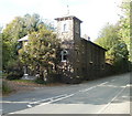
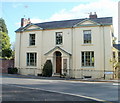
Stone house with tower, Monmouth Road, Abergavenny
Located on the west side of Monmouth Road, south of Station Road.
Image: © Jaggery
Taken: 20 Oct 2010
0.07 miles
2
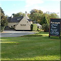
Plas Derwen Hotel, Abergavenny
Hotel with 11 en-suite rooms, bar and restaurant, located on the eastern side of Monmouth Road (A40), at the southern edge of Abergavenny.
Image: © Jaggery
Taken: 20 Oct 2010
0.08 miles
3
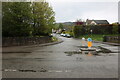
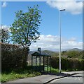
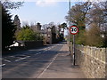
Plas Derwen Way at the junction of Monmouth Road
Abergavenny has recently become virtually all 20mph. Using the main roads is almost impossible in 3rd gear and causes unnecessary strings of traffic on otherwise clear roads.
Image: © David Howard
Taken: 23 Apr 2023
0.10 miles
4
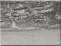
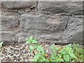
Ordnance Survey Cut Mark
This OS cut mark can be found on the wall NE side of Monmouth Road. It marks a point 61.036m above mean sea level.
Image: © Adrian Dust
Taken: 21 Aug 2023
0.11 miles
6
Ordnance Survey Cut Mark
This OS cut mark can be found on Cae Kenfy Lodge, Monmouth Road. It marks a point 60.695m above mean sea level.
Image: © Adrian Dust
Taken: 21 Aug 2023
0.12 miles
7
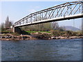
Pipe bridge over the Usk/Wysg
This bridge spans the river south of Abergavenny/Y Fenni. It leads directly to a sewage works on the west/south bank. In the distance the wooded slopes of Deri can be seen - a spur of Sugar Loaf/Y Fal.
Image: © Alan Bowring
Taken: 1 Apr 2007
0.12 miles
8
Gobannium Way, Abergavenny
Gobannium Way heads away from the west side of Monmouth Road (A40). Gobannium was a Roman fort and settlement within present-day Abergavenny.
In the distance is The Blorenge Image (561 metres or 1841 feet).
Image: © Jaggery
Taken: 20 Oct 2010
0.13 miles
9
Corner of Station Road and Monmouth Road, Abergavenny
The house on the corner has a Monmouth Road address, though most of the building, as seen here, faces Station Road.
Image: © Jaggery
Taken: 20 Oct 2010
0.13 miles
10
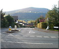
Entering Abergavenny
The A40 Monmouth Road entering Abergavenny from the south-east. As drivers enter the 30mph zone, a building with a distinctive tower is seen on the left.
Image: © Alan Bowring
Taken: 1 Apr 2007
0.14 miles