1
St Faith's Close, Llanfoist
Modern houses viewed from the corner of Gipsy Lane.
Image: © Jaggery
Taken: 22 Oct 2010
0.09 miles
2
St Faith's Close, Llanfoist
Cul-de-sac on the east side of the B4269 Gypsy Lane.
Image: © Jaggery
Taken: 11 Jun 2017
0.12 miles
3
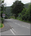
Warning sign - Patrol/Hebryngwr, Gypsy Lane, Llanfoist
The English/Welsh sign faces the B4269 Gypsy Lane on the approach to the village primary school.
Image: © Jaggery
Taken: 11 Jun 2017
0.13 miles
4
Electricity substation below a Llanfoist corner
The grey cabinet below the corner of St Faith's Close and Gypsy Lane is a
Western Power Distribution electricity substation. Its identifier is GYPSY LANE S/S 53-4001.
Image: © Jaggery
Taken: 11 Jun 2017
0.14 miles
5
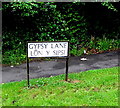
Bilingual lane name sign in Llanfoist
The sign on the right here http://www.geograph.org.uk/photo/5429257 shows that Gypsy Lane is Lôn y Sipsi in Welsh.
Image: © Jaggery
Taken: 11 Jun 2017
0.14 miles
6
Briardene, Llanfoist
Briardene is a cul-de-sac of about 50 modern houses on the north side of Merthyr Road.
Image: © Jaggery
Taken: 22 Oct 2010
0.15 miles
7
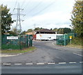
Council depot and pylon, Llanfoist
Monmouthshire County Council depot located on the west side of Merthyr Road, adjacent to the A465 (Heads of the Valleys Road) roundabout. The wording below the name on the sign on the left fence is
"No admittance to public".
Image: © Jaggery
Taken: 22 Oct 2010
0.15 miles
8
Northern end of the B4269, Llanfoist
The Sabre website states that the B4269 is a short route (1.9 miles (3.1 km)) south of Abergavenny in Monmouthshire connecting the A4042 at Llanellen with the B4246 here in Llanfoist.
The road on the right is a few metres from the B4246 junction.
Image: © Jaggery
Taken: 11 Jun 2017
0.15 miles
9
Llanfoist OAP Hall
Located along an unnamed lane a few metres south of the post office. http://www.geograph.org.uk/photo/2177882
Among the groups who meet here regularly are Castle Quilters and Llanfoist Poultry and Game Group.
Image: © Jaggery
Taken: 22 Oct 2010
0.15 miles
10
Llanfoist Post Office
Previously located nearby in The Cutting, Llanfoist Post Office is now in Llanfoist Church Hall, Merthyr Road. A sign on the right points to Llanfoist OAP Hall http://www.geograph.org.uk/photo/2177892.
Image: © Jaggery
Taken: 22 Oct 2010
0.15 miles


