IMAGES TAKEN NEAR TO
Llanover, ABERGAVENNY, NP7 9ED
Introduction
This page details the photographs taken nearby to NP7 9ED by members of the Geograph project.
The Geograph project started in 2005 with the aim of publishing, organising and preserving representative images for every square kilometre of Great Britain, Ireland and the Isle of Man.

There are currently over 7.5m images from over14,400 individuals and you can help contribute to the project by visiting https://www.geograph.org.uk
Image Map
Images are licensed for reuse under creativecommons.org/licenses/by-sa/2.0
Notes
- Clicking on the map will re-center to the selected point.
- The higher the marker number, the further away the image location is from the centre of the postcode.
Image Listing (57 Images Found)
Images are licensed for reuse under creativecommons.org/licenses/by-sa/2.0
Image
Details
Distance
1
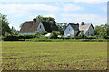
Houses south of Llanover church
The house on the left, Maes yr Afon, was Llanover parish school, 1835 - 1925, principally for children of estate workers on Llanover Estate. The house on the right, Tyr Ysgol, was the schoolhouse.
Image: © M J Roscoe
Taken: 8 Jun 2021
0.02 miles
2
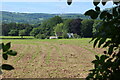
Arable field by road and River Usk
The houses Image on the edge of the field are by the side of the road.
Image: © M J Roscoe
Taken: 8 Jun 2021
0.03 miles
3
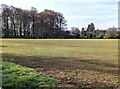
Field and distant trees, Llanover, Monmouthshire
Viewed from this https://www.geograph.org.uk/photo/7237734 gate in April 2022.
Image: © Jaggery
Taken: 17 Apr 2022
0.08 miles
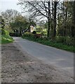
4
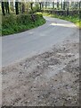
Bend in a minor road, Llanover
In rural Monmouthshire. A lychgate https://www.geograph.org.uk/photo/7237719 is nearby.
Image: © Jaggery
Taken: 17 Apr 2022
0.09 miles
5
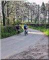
Sunday morning cyclists, Llanover, Monmouthshire
Travelling SE on a hedge-lined lane in April 2022.
Image: © Jaggery
Taken: 17 Apr 2022
0.10 miles
6
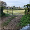
7-bar field gate, Llanover, Monmouthshire
Near St Bartholomew's churchyard.
Image: © Jaggery
Taken: 17 Apr 2022
0.12 miles
7
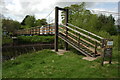
Suspension bridge, Llanover
A private suspension bridge over the River Usk at Llanover.
Image: © Philip Halling
Taken: 2 May 2009
0.12 miles
8
Minor road, Llanover, Monmouthshire
The road ahead is on the west bank of the River Usk.
Image: © Jaggery
Taken: 17 Apr 2022
0.12 miles
9
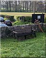
Memorial bench in the village churchyard, Llanover
The bench at the SE edge of St Bartholomew's churchyard is dedicated to the memory of Elisabeth Anna Hanson (August 23 1947 - June 7 2008).
Image: © Jaggery
Taken: 17 Apr 2022
0.13 miles
10
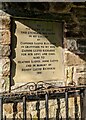
Tablet in the lychgate, Llanover, Monmouthshire
The tablet in this https://www.geograph.org.uk/photo/7237719 lychgate is dated 1991.
Image: © Jaggery
Taken: 17 Apr 2022
0.13 miles