IMAGES TAKEN NEAR TO
Llanarth, ABERGAVENNY, NP7 9BL
Introduction
This page details the photographs taken nearby to NP7 9BL by members of the Geograph project.
The Geograph project started in 2005 with the aim of publishing, organising and preserving representative images for every square kilometre of Great Britain, Ireland and the Isle of Man.

There are currently over 7.5m images from over14,400 individuals and you can help contribute to the project by visiting https://www.geograph.org.uk
Image Map
Images are licensed for reuse under creativecommons.org/licenses/by-sa/2.0
Notes
- Clicking on the map will re-center to the selected point.
- The higher the marker number, the further away the image location is from the centre of the postcode.
Image Listing (9 Images Found)
Images are licensed for reuse under creativecommons.org/licenses/by-sa/2.0
Image
Details
Distance
1
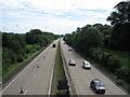
The A40 by Clytha Park
Looking towards Raglan. Abergavenny is behind the camera.
Image: © Roy Parkhouse
Taken: 19 Jul 2007
0.14 miles
2
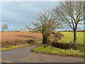
Lane to Llansantffraed
Red House can be seen beyond the red field to the left.
Image: © Jonathan Billinger
Taken: 28 Jan 2010
0.16 miles
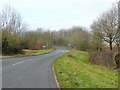
4
Bend in the road away from Llanarth, Monmouthshire
Ahead for Llanvihangel Gobion. Behind the camera for Llanarth.
Image: © Jaggery
Taken: 6 Sep 2020
0.20 miles
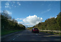
5
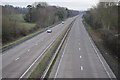
The A40 near Clytha Park
The A40 near Clytha Park viewed from the bridge carrying the road to Lanarth.
Image: © Philip Halling
Taken: 14 Jan 2012
0.21 miles
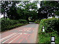
6
Groesonen Road
Looking west as it rises to go over the A40.
The lane to the left leads to Red House and Llansantffraed.
Image: © Jonathan Billinger
Taken: 28 Jan 2010
0.22 miles
7
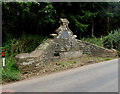
Old water trough near Llanarth, Monmouthshire
The trough contains water in September 2020 - but you wouldn't want to drink it. https://www.geograph.org.uk/photo/6594466
Image: © Jaggery
Taken: 6 Sep 2020
0.23 miles
8
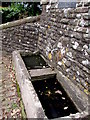
Undrinkable contents of an old water trough near Llanarth, Monmouthshire
The contents of this https://www.geograph.org.uk/photo/6594456 old trough in September 2020.
Image: © Jaggery
Taken: 6 Sep 2020
0.23 miles
9
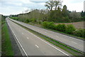
A40 towards Raglan
This is the new road, a long dual carriageway built in the 1970s, to replace the old section between Abergavenny and Raglan. There is an ancient site marked on the map here, Twyn-y-Gregan, which must be by the trees beyond the ploughed field on the right.
Image: © Graham Horn
Taken: 13 Apr 2012
0.24 miles