IMAGES TAKEN NEAR TO
Penpergwm, ABERGAVENNY, NP7 9AR
Introduction
This page details the photographs taken nearby to NP7 9AR by members of the Geograph project.
The Geograph project started in 2005 with the aim of publishing, organising and preserving representative images for every square kilometre of Great Britain, Ireland and the Isle of Man.

There are currently over 7.5m images from over14,400 individuals and you can help contribute to the project by visiting https://www.geograph.org.uk
Image Map
Images are licensed for reuse under creativecommons.org/licenses/by-sa/2.0
Notes
- Clicking on the map will re-center to the selected point.
- The higher the marker number, the further away the image location is from the centre of the postcode.
Image Listing (30 Images Found)
Images are licensed for reuse under creativecommons.org/licenses/by-sa/2.0
Image
Details
Distance
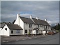
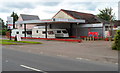
1
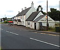
The King of Prussia, Penpergwm
The King of Prussia Public House lies on the southern side of the B4598 in the village of Penpergwm.
It is shown on the 1881 edition of the Ordnance Survey map.
Like many rural pubs it has suffered from loss of trade and has been closed for years.
It sits in front of a plant hire company who have sought permission to demolish it.
The local council are questioning some details, but it seems its fate is sealed.
Image: © Colin Cheesman
Taken: 3 Sep 2023
0.02 miles
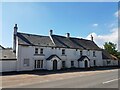
2
The King of Prussia, Penpergwm
This name is thought to be originate in celebration of Frederick the Great an ally of the British in the 18th century. It has been stated that the name was Changed to the King of Russia during WW1, finally reverting later in the century.
Image: © Chris Andrews
Taken: 12 Apr 2016
0.02 miles

4
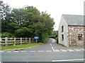
Minor road opposite The King of Prussia, Penpergwm
Viewed from the edge of this country pub. http://www.geograph.org.uk/photo/3044014
The minor road heads north away from Old Raglan Road (B4598). There are three signs at the junction.
The largest one, white on blue, shows Unsuitable for heavy goods vehicles
The one on the left shows 2 miles to Chapel Cottage.
The smallest one shows BAPTIST CHAPEL but does not show the distance.
Image: © Jaggery
Taken: 15 Jul 2012
0.04 miles
5
The King of Prussia, Penpergwm viewed from the west
The country pub is alongside Old Raglan Road (B4598) in Penpergwm, between Abergavenny and Raglan. Though there are other pubs in the UK named The King of Prussia, some which originally bore that name were renamed, especially at the time of strong anti-German sentiment during the Great War, later known as the First World War. This link http://www.geograph.org.uk/photo/3044130 gives some details which suggest a possible reason for the name's survival.
Image: © Jaggery
Taken: 15 Jul 2012
0.04 miles
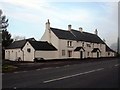
6
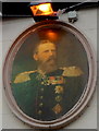
Portrait of Kaiser Friedrich III, The King of Prussia pub, Penpergwm
This portrait is on the front wall of the pub http://www.geograph.org.uk/photo/3044014 and also in the pub signs.
It is of Kaiser Friedrich III, usually known in English as Frederick III. It may appear strange than a country pub was named after a Prussian, and more so, that the name survived the strong anti-German sentiment during the First World War.
Although the stereotypical Prussian of this period is often considered to be arrogantly militaristic, Frederick III was in many ways not a typical Prussian.
He was married to Princess Victoria, eldest daughter of Queen Victoria. His wife supported and shared his liberal ideology which led them to seek greater representation for commoners in the government of Germany. Frederick, despite his conservative militaristic family background, had developed liberal tendencies from his ties with Britain and his studies at the University of Bonn. He also professed a hatred for warfare.
Liberals in both Germany and Britain hoped that as emperor, Frederick III would liberalise the German Empire. However, Frederick spent nearly 30 years as heir to the throne, with little real power. When he became Kaiser on the death of his father in 1888, Frederick had already contracted a cancer that would prove fatal. He was Kaiser for only 99 days. On his death in June 1888, he was succeeded by his son, Wilhelm (William II), who reversed the few changes that Frederick made. Wilhelm was Kaiser throughout the First World War.
Frederick's premature death is considered a potential turning point in German history. Whether or not he would have made the German Empire more liberal if he had lived longer is a matter of opinion.
Perhaps the name of the pub survived through the First World War because of the respect he had earned in Britain a generation earlier.
Image: © Jaggery
Taken: 15 Jul 2012
0.04 miles
7
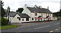
The King of Prussia, Penpergwm viewed from the east
The country pub is alongside Old Raglan Road (B4598) in Penpergwm, between Abergavenny and Raglan. Though there are other pubs in the UK named The King of Prussia, some which originally bore that name were renamed, especially at the time of strong anti-German sentiment during the Great War, later known as the First World War. This link http://www.geograph.org.uk/photo/3044130 gives some details which suggest a possible reason for the name's survival.
Image: © Jaggery
Taken: 15 Jul 2012
0.04 miles
8
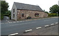
Kingfields, Penpergwm
Kingfields is a former barn converted to residential use, located on Old Raglan Road (B4598) opposite The King of Prussia. http://www.geograph.org.uk/photo/3044374
Image: © Jaggery
Taken: 15 Jul 2012
0.04 miles
9
Hockey Garage, Penpergwm
The garage, including Abergavenny Caravan Leisure, is on the south side of Old Raglan Road (B4598).
Image: © Jaggery
Taken: 15 Jul 2012
0.05 miles