IMAGES TAKEN NEAR TO
Llantilio Crossenny, ABERGAVENNY, NP7 8TN
Introduction
This page details the photographs taken nearby to NP7 8TN by members of the Geograph project.
The Geograph project started in 2005 with the aim of publishing, organising and preserving representative images for every square kilometre of Great Britain, Ireland and the Isle of Man.

There are currently over 7.5m images from over14,400 individuals and you can help contribute to the project by visiting https://www.geograph.org.uk
Image Map (Loading...)


Getting Data...Please wait
Leaflet Map data © OpenStreetMap
Images are licensed for reuse under creativecommons.org/licenses/by-sa/2.0
Notes
- Clicking on the map will re-center to the selected point.
- The higher the marker number, the further away the image location is from the centre of the postcode.
Image Listing (7 Images Found)
Images are licensed for reuse under creativecommons.org/licenses/by-sa/2.0
Image
Details
Distance
1
East of Llantilio Crossenny
The Offa's Dyke Path takes a varied route through low farmland between Monmouth and Pandy. Here is one of the welcome road sections; welcome if the fields are waterlogged as they were on this day. Ysgyryd Fawr is always in view ahead (except when covered in mist).
Image: © Graham Horn
Taken: 17 Apr 2000
0.02 miles
2
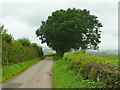
Road to Llantilio Crossenny
Approaching Nantyderri Farm from the east.
Image: © Jonathan Billinger
Taken: 19 Aug 2008
0.03 miles
3
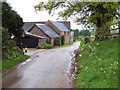
Nantyderri Farm
Situated on a narrow lane south of Llantilio Crossenny, which is also utilised by the Offa's Dyke National Trail
Image: © Chris Heaton
Taken: 8 May 2006
0.07 miles
4
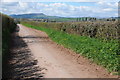
Country road near Nantyderri Farm
For those walking Offa's Dyke Path walking along this roar towards Llantilio Crossenny will offer a tantilising of the Black Mountains and the highest part of the entire long distance path.
Image: © Philip Halling
Taken: 27 Apr 2013
0.07 miles
5
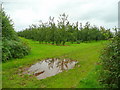
Cider orchards 1
South-west of the road from Penrhos to Nantyderri Farm.
Image: © Jonathan Billinger
Taken: 19 Aug 2008
0.08 miles
6
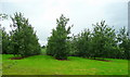
Cider orchards 2
South-east of the road from Penrhos to Nantyderri Farm.
Grown for Bulmers in Hereford.
Image: © Jonathan Billinger
Taken: 19 Aug 2008
0.12 miles
7
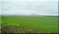
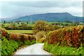
View north from near Nantyderri Farm
The hill in the distance is Edmund's Tump (423m).
Image: © Jonathan Billinger
Taken: 19 Aug 2008
0.12 miles