IMAGES TAKEN NEAR TO
Llanvetherine, ABERGAVENNY, NP7 8RF
Introduction
This page details the photographs taken nearby to NP7 8RF by members of the Geograph project.
The Geograph project started in 2005 with the aim of publishing, organising and preserving representative images for every square kilometre of Great Britain, Ireland and the Isle of Man.

There are currently over 7.5m images from over14,400 individuals and you can help contribute to the project by visiting https://www.geograph.org.uk
Image Map
Images are licensed for reuse under creativecommons.org/licenses/by-sa/2.0
Notes
- Clicking on the map will re-center to the selected point.
- The higher the marker number, the further away the image location is from the centre of the postcode.
Image Listing (5 Images Found)
Images are licensed for reuse under creativecommons.org/licenses/by-sa/2.0
Image
Details
Distance
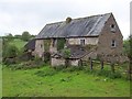
2
Ramshackle old farmhouse beside Offa's Dyke Path in Monmouthshire
This splendid old farmhouse is degenerating steadily with large holes in the roof slates and open or missing window glass. Its future prospects look poor unless it is redeveloped. What's the story here I wonder? Maybe it is structurally unsound.
Image: © Jeremy Bolwell
Taken: 6 Sep 2010
0.03 miles
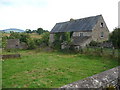
3
Little Pool Hall
The Offa's Dyke National Trail passes by this fine farmhouse, now deserted and slowly falling into disrepair
Image: © Chris Heaton
Taken: 9 May 2006
0.03 miles
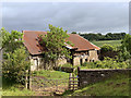
4
Ffarm Little Pool Farm
Ysgubor llafur Ffarm Little Pool. Mae Llwybr Clawdd Offa yn mynd heibio iddo.
Little Pool Farm corn barn. The Offa's Dyke Path passes alongside it.
Image: © Alan Richards
Taken: 21 Aug 1997
0.03 miles
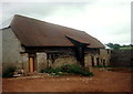
5
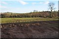
Farmland and Offa's Dyke Path
Offa's Dyke Path crossing this field near Llangattock Lingoed.
Image: © Philip Halling
Taken: 15 Mar 2014
0.24 miles