IMAGES TAKEN NEAR TO
Poorscript Lane, ABERGAVENNY, NP7 8LP
Introduction
This page details the photographs taken nearby to Poorscript Lane, NP7 8LP by members of the Geograph project.
The Geograph project started in 2005 with the aim of publishing, organising and preserving representative images for every square kilometre of Great Britain, Ireland and the Isle of Man.

There are currently over 7.5m images from over14,400 individuals and you can help contribute to the project by visiting https://www.geograph.org.uk
Image Map
Images are licensed for reuse under creativecommons.org/licenses/by-sa/2.0
Notes
- Clicking on the map will re-center to the selected point.
- The higher the marker number, the further away the image location is from the centre of the postcode.
Image Listing (216 Images Found)
Images are licensed for reuse under creativecommons.org/licenses/by-sa/2.0
Image
Details
Distance
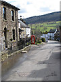
1
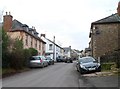
Looking north along the main road through Grosmont
Looking towards Kentchurch from near the Poorscript Lane junction. http://www.geograph.org.uk/photo/2812407
Grade II* listed Glyndŵr http://www.geograph.org.uk/photo/2812626 is on the left.
Rock Villa http://www.geograph.org.uk/photo/2812341 is on the right.
Image: © Jaggery
Taken: 19 Feb 2012
0.02 miles
2
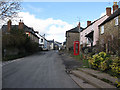
B4347 passing through Grosmont
Heading for Cupid's Hill and Pontrilas.
Image: © Pauline E
Taken: 4 Mar 2009
0.04 miles
3
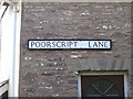
Unusual street name
Poorscript Lane. Anyone know the origin of this?
Image: © Pauline E
Taken: 4 Mar 2009
0.04 miles
4
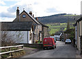
Parcel delivery
The postman is on his rounds in Grosmont. The view south is of Graig Syfyrddin (423m). The B4347 runs through the village.
Image: © Pauline E
Taken: 4 Mar 2009
0.04 miles
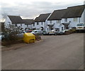
5
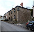
Rock Villa and Myrtle Cottage, Grosmont
Two houses on the east side of the B4347, the main road through the village.
Image: © Jaggery
Taken: 19 Feb 2012
0.05 miles
6
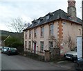
Grade II* listed Glyndŵr, Grosmont
Glyndŵr is located on the corner of the main road through Grosmont (B4347) and Poorscript Lane. The date stone above the central upper storey window shows 1742. Grade II* listed in September 1956.
Image: © Jaggery
Taken: 19 Feb 2012
0.05 miles
7
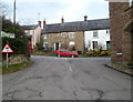
Grosmont road junction
Viewed from opposite York House. http://www.geograph.org.uk/photo/2812663
Turn left ahead at the B4347 for Pontrilas (3 miles) or right for Skenfrith (5 miles).
Image: © Jaggery
Taken: 19 Feb 2012
0.05 miles
8
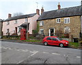
Two listed houses and a listed phonebox, Grosmont
The pink house is The Steppes, which may have been built as two cottages centuries ago. Grade II listed in October 2000. Next door is Whitney Villa, dating from the seventeenth century. Grade II listed in October 2000.
Surprisingly perhaps, the two houses weren't listed until a decade after the red phone box, Grade II listed in October 1990.
Image: © Jaggery
Taken: 19 Feb 2012
0.05 miles
9
K6 phonebox in Grosmont
Looking south towards the slopes of Graig Syfyrddin.
Image: © Pauline E
Taken: 4 Mar 2009
0.05 miles
10
Bevan Court, Grosmont
Modern houses on the west side of the B4347, the main road through the village.
Image: © Jaggery
Taken: 19 Feb 2012
0.05 miles