IMAGES TAKEN NEAR TO
Wellfield, ABERGAVENNY, NP7 8EQ
Introduction
This page details the photographs taken nearby to Wellfield, NP7 8EQ by members of the Geograph project.
The Geograph project started in 2005 with the aim of publishing, organising and preserving representative images for every square kilometre of Great Britain, Ireland and the Isle of Man.

There are currently over 7.5m images from over14,400 individuals and you can help contribute to the project by visiting https://www.geograph.org.uk
Image Map
Images are licensed for reuse under creativecommons.org/licenses/by-sa/2.0
Notes
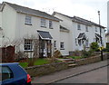
- Clicking on the map will re-center to the selected point.
- The higher the marker number, the further away the image location is from the centre of the postcode.
Image Listing (214 Images Found)
Images are licensed for reuse under creativecommons.org/licenses/by-sa/2.0
Image
Details
Distance
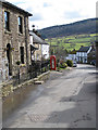
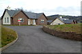
2
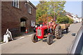
Bevan Court, Grosmont
Modern houses on the west side of the B4347, the main road through the village.
Image: © Jaggery
Taken: 19 Feb 2012
0.03 miles
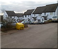
3
Row of three white houses, Grosmont
Located on the corner of the B4347 and Wellfield are Swallow House, Swallow Cottage and Ty Celyn.
I wondered whether Celyn is Welsh for swallow. No - it's Welsh for holly.
Image: © Jaggery
Taken: 19 Feb 2012
0.03 miles
4
Parcel delivery
The postman is on his rounds in Grosmont. The view south is of Graig Syfyrddin (423m). The B4347 runs through the village.
Image: © Pauline E
Taken: 4 Mar 2009
0.03 miles
5
K6 phonebox in Grosmont
Looking south towards the slopes of Graig Syfyrddin.
Image: © Pauline E
Taken: 4 Mar 2009
0.05 miles
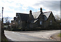
6
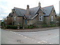
Grade II listed The Old School, Grosmont
The former Grosmont Junior and Infants County School is on the corner of the B4347 and the road to Abergavenny. Grade II listed in September 1990.
The nearest primary school is about 3 miles (c5km) away, in Cross Ash.
Image: © Jaggery
Taken: 19 Feb 2012
0.05 miles
7
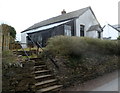
Former Grosmont Mission Hall
Steps from the road to Abergavenny lead up to the closed Grosmont Mission Hall.
Image: © Jaggery
Taken: 19 Feb 2012
0.05 miles
8
Road from Abergavenny reaches Grosmont
Looking along the eastern end of the road from Abergavenny. Ahead is the B4347 junction. The Old School is on the right. Turn left for Kentchurch (1½ miles) or Hereford (11 miles).
Turn right for Grosmont castle, church and the centre of the village. Skenfrith is 5 miles away and Monmouth 11 miles.
Image: © Jaggery
Taken: 19 Feb 2012
0.06 miles
9
The Gate House, Grosmont
Detached bungalow set back from the east side of the B4347.
Image: © Jaggery
Taken: 19 Feb 2012
0.06 miles
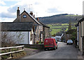
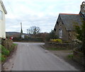
10
Right turn to Abergavenny
The building, now a dwelling appears to be a former school with a date stone of 1877. (Possibly the Board School).
Image: © Pauline E
Taken: 4 Mar 2009
0.06 miles