IMAGES TAKEN NEAR TO
Llanvihangel Crucorney, ABERGAVENNY, NP7 8EL
Introduction
This page details the photographs taken nearby to NP7 8EL by members of the Geograph project.
The Geograph project started in 2005 with the aim of publishing, organising and preserving representative images for every square kilometre of Great Britain, Ireland and the Isle of Man.

There are currently over 7.5m images from over14,400 individuals and you can help contribute to the project by visiting https://www.geograph.org.uk
Image Map
Images are licensed for reuse under creativecommons.org/licenses/by-sa/2.0
Notes
- Clicking on the map will re-center to the selected point.
- The higher the marker number, the further away the image location is from the centre of the postcode.
Image Listing (12 Images Found)
Images are licensed for reuse under creativecommons.org/licenses/by-sa/2.0
Image
Details
Distance
1
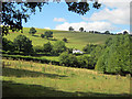
The Arwallt
Looking north-west to the rounded dome of The Arwallt, which is mainly sheep grazing land. The white cottage sits on Hill Street, which traverses the hillside just below the large fields.
Image: © Trevor Rickard
Taken: 11 Aug 2010
0.04 miles
2
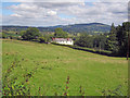
Pwll-llaca House
Viewed from Hill Street, the house makes a striking contrast to the verdant countryside. In the distance is Graig Syfyrddin. The smaller hill directly above the house is Garway Hill.
Image: © Trevor Rickard
Taken: 11 Aug 2010
0.05 miles
3
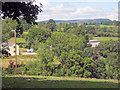
Pwll-llaca Farm
View north-west to the farm buildings, partially hidden by trees. In the distance is Hatterrall Hill on the Black Mountains.
Image: © Trevor Rickard
Taken: 11 Aug 2010
0.11 miles
4
Pwll-llaca Farm
Farmland and Pwll-llaca Farm near Llangattock Lingoed.
Image: © Philip Halling
Taken: 15 Mar 2014
0.11 miles
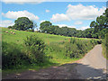
5
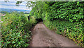
Hill Street
A very narrow lane to the north-east of The Skirrid.
Image: © Jonathan Billinger
Taken: 5 Jul 2022
0.14 miles
6
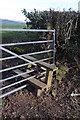
Unusual stile
Not sure that this gate can be used as the stile is a fixture.
Image: © Philip Halling
Taken: 15 Mar 2014
0.15 miles
7
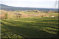
Long shadows at the end of the day
Long shadows cast across farmland near Llangattock Lingoed.
Image: © Philip Halling
Taken: 15 Mar 2014
0.15 miles
8
Rolling Monmouthshire countryside
Looking north-east from a narrow lane named Hill Street.
Image: © Jonathan Billinger
Taken: 5 Jul 2022
0.18 miles
9
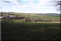
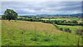
Sheep grazing near Great Park Road
View north from the bend in the lane with the slopes of The Arwallt on the left.
Image: © Trevor Rickard
Taken: 11 Aug 2010
0.18 miles
10

Farmland near Pen-y-parc
Looking north-east across rolling hills to Graig Syfyrddin. Pen-rhos farm buildings on the ridge in the middle distance.
Image: © Trevor Rickard
Taken: 11 Aug 2010
0.19 miles